

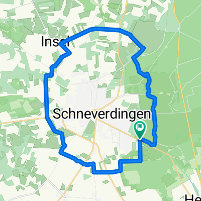
Tour 14 - Rund um Schneverdingen
A cycling route starting in Schneverdingen, Lower Saxony, Germany.
Overview
About this route
track uploaded with updater tool
- -:--
- Duration
- 34.6 km
- Distance
- 90 m
- Ascent
- 111 m
- Descent
- ---
- Avg. speed
- ---
- Max. altitude
Route quality
Waytypes & surfaces along the route
Waytypes
Quiet road
16.2 km
(47 %)
Track
8.6 km
(25 %)
Surfaces
Paved
16.2 km
(47 %)
Unpaved
10 km
(29 %)
Asphalt
12.8 km
(37 %)
Unpaved (undefined)
5.2 km
(15 %)
Continue with Bikemap
Use, edit, or download this cycling route
You would like to ride Tour 14 - Rund um Schneverdingen or customize it for your own trip? Here is what you can do with this Bikemap route:
Free features
- Save this route as favorite or in collections
- Copy & plan your own version of this route
- Sync your route with Garmin or Wahoo
Premium features
Free trial for 3 days, or one-time payment. More about Bikemap Premium.
- Navigate this route on iOS & Android
- Export a GPX / KML file of this route
- Create your custom printout (try it for free)
- Download this route for offline navigation
Discover more Premium features.
Get Bikemap PremiumFrom our community
Other popular routes starting in Schneverdingen
 4_TourRundumSchneverdingen
- Distance
- 22.3 km
- Ascent
- 76 m
- Descent
- 76 m
- Location
- Schneverdingen, Lower Saxony, Germany
 Heber 14 km
- Distance
- 14 km
- Ascent
- 44 m
- Descent
- 37 m
- Location
- Schneverdingen, Lower Saxony, Germany
 Melkhus Fintel
- Distance
- 28 km
- Ascent
- 58 m
- Descent
- 55 m
- Location
- Schneverdingen, Lower Saxony, Germany
 13.10.13
- Distance
- 43.5 km
- Ascent
- 216 m
- Descent
- 218 m
- Location
- Schneverdingen, Lower Saxony, Germany
 Tag 4Schneverdingen-Höpen-Forst
- Distance
- 29.1 km
- Ascent
- 90 m
- Descent
- 90 m
- Location
- Schneverdingen, Lower Saxony, Germany
 Heiderunde - Start an der KGS Schneverdingen
- Distance
- 28.7 km
- Ascent
- 100 m
- Descent
- 100 m
- Location
- Schneverdingen, Lower Saxony, Germany
 Durch die Heide
- Distance
- 42.1 km
- Ascent
- 182 m
- Descent
- 180 m
- Location
- Schneverdingen, Lower Saxony, Germany
 Rund um Schneverdingen
- Distance
- 45.1 km
- Ascent
- 91 m
- Descent
- 90 m
- Location
- Schneverdingen, Lower Saxony, Germany
Open it in the app