

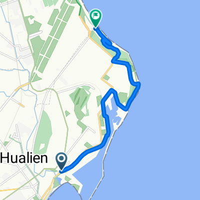
蘇花
A cycling route starting in Hualien City, Taiwan, Taiwan.
Overview
About this route
27/6/147:36
- -:--
- Duration
- 39.2 km
- Distance
- 661 m
- Ascent
- 649 m
- Descent
- ---
- Avg. speed
- ---
- Max. altitude

Route quality
Waytypes & surfaces along the route
Waytypes
Access road
1.6 km
(4 %)
Road
0.4 km
(1 %)
Surfaces
Paved
36.8 km
(94 %)
Asphalt
36.8 km
(94 %)
Undefined
2.3 km
(6 %)
Continue with Bikemap
Use, edit, or download this cycling route
You would like to ride 蘇花 or customize it for your own trip? Here is what you can do with this Bikemap route:
Free features
- Save this route as favorite or in collections
- Copy & plan your own version of this route
- Sync your route with Garmin or Wahoo
Premium features
Free trial for 3 days, or one-time payment. More about Bikemap Premium.
- Navigate this route on iOS & Android
- Export a GPX / KML file of this route
- Create your custom printout (try it for free)
- Download this route for offline navigation
Discover more Premium features.
Get Bikemap PremiumFrom our community
Other popular routes starting in Hualien City
 七星潭單車道
- Distance
- 9.7 km
- Ascent
- 44 m
- Descent
- 49 m
- Location
- Hualien City, Taiwan, Taiwan
 一日北高三日環島衝衝衝【花北段】
- Distance
- 186.2 km
- Ascent
- 2,059 m
- Descent
- 2,087 m
- Location
- Hualien City, Taiwan, Taiwan
 武嶺-1 (Wuling)
- Distance
- 88.8 km
- Ascent
- 5,053 m
- Descent
- 1,810 m
- Location
- Hualien City, Taiwan, Taiwan
 樂虎LOVE 兩日東進武嶺(第一天)
- Distance
- 70.6 km
- Ascent
- 4,065 m
- Descent
- 1,722 m
- Location
- Hualien City, Taiwan, Taiwan
 花蓮雙潭輕鬆騎
- Distance
- 91.8 km
- Ascent
- 677 m
- Descent
- 679 m
- Location
- Hualien City, Taiwan, Taiwan
 Luodong
- Distance
- 99.8 km
- Ascent
- 1,728 m
- Descent
- 1,776 m
- Location
- Hualien City, Taiwan, Taiwan
 Hualien to Taroko
- Distance
- 34.8 km
- Ascent
- 131 m
- Descent
- 81 m
- Location
- Hualien City, Taiwan, Taiwan
 花蓮台東7天環花東
- Distance
- 392.7 km
- Ascent
- 1,105 m
- Descent
- 1,103 m
- Location
- Hualien City, Taiwan, Taiwan
Open it in the app