Kripo Radtour 2014 - 2. Tag
A cycling route starting in Dettelbach, Bavaria, Germany.
Overview
About this route
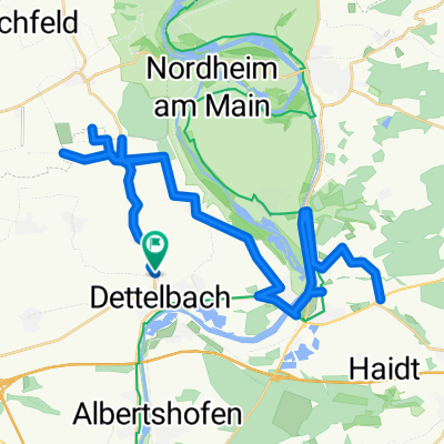
Start in Hörblach Dettelbach - Neuses am Berg - Escherndorf - (Vogelburg) - Volkach - Nordheim - Sommerach - Schwarzach - Dettelbach - Dettelbach Station
- -:--
 - Duration
 - 47 km
 - Distance
 - 352 m
 - Ascent
 - 258 m
 - Descent
 - ---
 - Avg. speed
 - ---
 - Max. altitude
 
Route quality
Waytypes & surfaces along the route
Waytypes
Road
18.3 km
(39 %)
Path
2.3 km
(5 %)
Surfaces
Paved
41.8 km
(89 %)
Unpaved
0.5 km
(1 %)
Asphalt
41.3 km
(88 %)
Paved (undefined)
0.5 km
(1 %)
Continue with Bikemap
Use, edit, or download this cycling route
You would like to ride Kripo Radtour 2014 - 2. Tag or customize it for your own trip? Here is what you can do with this Bikemap route:
Free features
- Save this route as favorite or in collections
 - Copy & plan your own version of this route
 - Sync your route with Garmin or Wahoo
 
Premium features
Free trial for 3 days, or one-time payment. More about Bikemap Premium.
- Navigate this route on iOS & Android
 - Export a GPX / KML file of this route
 - Create your custom printout (try it for free)
 - Download this route for offline navigation
 
Discover more Premium features.
Get Bikemap PremiumFrom our community
Other popular routes starting in Dettelbach
Tag 4 Dettelbach/Bad Bocklet- Distance
 - 73.8 km
 - Ascent
 - 301 m
 - Descent
 - 260 m
 - Location
 - Dettelbach, Bavaria, Germany
 
Dettelbach - Retzstadt- Distance
 - 70.9 km
 - Ascent
 - 109 m
 - Descent
 - 73 m
 - Location
 - Dettelbach, Bavaria, Germany
 
Dettelb- Route 1 kurz- Distance
 - 17.1 km
 - Ascent
 - 194 m
 - Descent
 - 195 m
 - Location
 - Dettelbach, Bavaria, Germany
 
Etappe_06_bike- Distance
 - 46.2 km
 - Ascent
 - 70 m
 - Descent
 - 106 m
 - Location
 - Dettelbach, Bavaria, Germany
 
Mainschleife: Mainsondheim-Volkach retour- Distance
 - 33.3 km
 - Ascent
 - 210 m
 - Descent
 - 210 m
 - Location
 - Dettelbach, Bavaria, Germany
 
Dettelbach in den Steigerwald- Distance
 - 67.5 km
 - Ascent
 - 767 m
 - Descent
 - 754 m
 - Location
 - Dettelbach, Bavaria, Germany
 
Genießer-Tour (Tour 2) - Genießer-Tour (Tour 2)- Distance
 - 41 km
 - Ascent
 - 228 m
 - Descent
 - 226 m
 - Location
 - Dettelbach, Bavaria, Germany
 
Am Steinbühl, Dettelbach nach Am Steinbühl, Dettelbach- Distance
 - 21.8 km
 - Ascent
 - 135 m
 - Descent
 - 141 m
 - Location
 - Dettelbach, Bavaria, Germany
 
Open it in the app


