

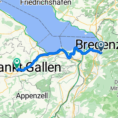
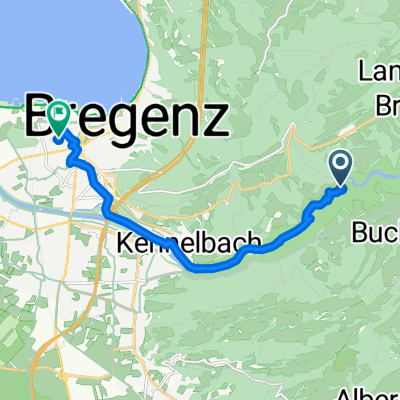
Pfänder Trail von Fluh
A cycling route starting in Kennelbach, Vorarlberg, Austria.
Overview
About this route
- teilweise Steile und ruppige Passagen
- -:--
- Duration
- 1.3 km
- Distance
- 0 m
- Ascent
- 330 m
- Descent
- ---
- Avg. speed
- ---
- Max. altitude
Continue with Bikemap
Use, edit, or download this cycling route
You would like to ride Pfänder Trail von Fluh or customize it for your own trip? Here is what you can do with this Bikemap route:
Free features
- Save this route as favorite or in collections
- Copy & plan your own version of this route
- Sync your route with Garmin or Wahoo
Premium features
Free trial for 3 days, or one-time payment. More about Bikemap Premium.
- Navigate this route on iOS & Android
- Export a GPX / KML file of this route
- Create your custom printout (try it for free)
- Download this route for offline navigation
Discover more Premium features.
Get Bikemap PremiumFrom our community
Other popular routes starting in Kennelbach
 Slow Freitag Route In Kennelbach
- Distance
- 8.1 km
- Ascent
- 660 m
- Descent
- 33 m
- Location
- Kennelbach, Vorarlberg, Austria
 bregenz - weiler simmerberg - scheidegg
- Distance
- 40.4 km
- Ascent
- 612 m
- Descent
- 697 m
- Location
- Kennelbach, Vorarlberg, Austria
 Bucher Straße 52-54, Wolfurt nach Blütenweg 5a, Wolfurt
- Distance
- 53.2 km
- Ascent
- 872 m
- Descent
- 926 m
- Location
- Kennelbach, Vorarlberg, Austria
 Kennelbach - Gaiserwald
- Distance
- 45.9 km
- Ascent
- 362 m
- Descent
- 162 m
- Location
- Kennelbach, Vorarlberg, Austria
 Bregenzer Wald groß
- Distance
- 124.8 km
- Ascent
- 2,216 m
- Descent
- 2,216 m
- Location
- Kennelbach, Vorarlberg, Austria
 kennelbach alte bahntrasse
- Distance
- 10.7 km
- Ascent
- 76 m
- Descent
- 115 m
- Location
- Kennelbach, Vorarlberg, Austria
 Radrunde zum zwergi
- Distance
- 12.1 km
- Ascent
- 26 m
- Descent
- 171 m
- Location
- Kennelbach, Vorarlberg, Austria
 Wälderbähnle
- Distance
- 8.4 km
- Ascent
- 461 m
- Descent
- 426 m
- Location
- Kennelbach, Vorarlberg, Austria
Open it in the app