

Ardara_Camping_Derrylahan_Dia4_parte2
A cycling route starting in Killybegs, Ulster, Ireland.
Overview
About this route
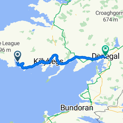
Second part of day 4. Arrival at the Derrylahan campsite
- -:--
- Duration
- 25.4 km
- Distance
- 364 m
- Ascent
- 329 m
- Descent
- ---
- Avg. speed
- ---
- Max. altitude
Route quality
Waytypes & surfaces along the route
Waytypes
Road
8.4 km
(33 %)
Quiet road
0.3 km
(1 %)
Undefined
16.7 km
(66 %)
Surfaces
Paved
20.8 km
(82 %)
Asphalt
20.8 km
(82 %)
Undefined
4.6 km
(18 %)
Continue with Bikemap
Use, edit, or download this cycling route
You would like to ride Ardara_Camping_Derrylahan_Dia4_parte2 or customize it for your own trip? Here is what you can do with this Bikemap route:
Free features
- Save this route as favorite or in collections
- Copy & plan your own version of this route
- Sync your route with Garmin or Wahoo
Premium features
Free trial for 3 days, or one-time payment. More about Bikemap Premium.
- Navigate this route on iOS & Android
- Export a GPX / KML file of this route
- Create your custom printout (try it for free)
- Download this route for offline navigation
Discover more Premium features.
Get Bikemap PremiumFrom our community
Other popular routes starting in Killybegs
 tour2008g1
- Distance
- 59.5 km
- Ascent
- 625 m
- Descent
- 582 m
- Location
- Killybegs, Ulster, Ireland
 100K for Leitr
- Distance
- 100.5 km
- Ascent
- 1,043 m
- Descent
- 1,098 m
- Location
- Killybegs, Ulster, Ireland
 Derrylahan_Donega_Dia5_parte1
- Distance
- 43.4 km
- Ascent
- 434 m
- Descent
- 489 m
- Location
- Killybegs, Ulster, Ireland
 Killybegs to Belfast edited
- Distance
- 444.8 km
- Ascent
- 4,802 m
- Descent
- 4,824 m
- Location
- Killybegs, Ulster, Ireland
 Ardara_Camping_Derrylahan_Dia4_parte2
- Distance
- 25.4 km
- Ascent
- 364 m
- Descent
- 329 m
- Location
- Killybegs, Ulster, Ireland
 100km walk
- Distance
- 100.4 km
- Ascent
- 891 m
- Descent
- 963 m
- Location
- Killybegs, Ulster, Ireland
 Home1
Home1- Distance
- 30.8 km
- Ascent
- 320 m
- Descent
- 345 m
- Location
- Killybegs, Ulster, Ireland
 Z1 loop
- Distance
- 26.6 km
- Ascent
- 371 m
- Descent
- 374 m
- Location
- Killybegs, Ulster, Ireland
Open it in the app