

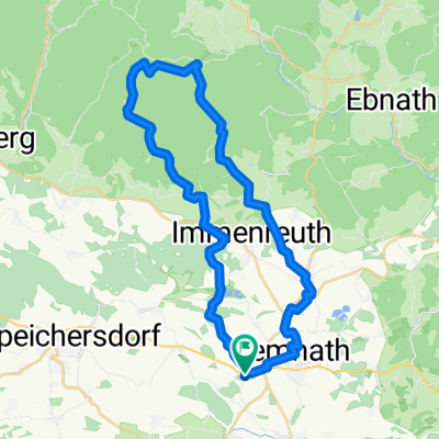
Feierabendrunde Pressath - Grafenwöhr
A cycling route starting in Kemnath, Bavaria, Germany.
Overview
About this route
über Hessenreuth, Riggau, Döllnitz, Dießfurth, Grafenwöhr und Pressath
- -:--
- Duration
- 51.1 km
- Distance
- 407 m
- Ascent
- 409 m
- Descent
- ---
- Avg. speed
- ---
- Max. altitude
Route quality
Waytypes & surfaces along the route
Waytypes
Busy road
19.8 km
(39 %)
Road
18.7 km
(36 %)
Surfaces
Paved
45.9 km
(90 %)
Unpaved
2.2 km
(4 %)
Asphalt
45.8 km
(90 %)
Ground
1.8 km
(3 %)
Continue with Bikemap
Use, edit, or download this cycling route
You would like to ride Feierabendrunde Pressath - Grafenwöhr or customize it for your own trip? Here is what you can do with this Bikemap route:
Free features
- Save this route as favorite or in collections
- Copy & plan your own version of this route
- Sync your route with Garmin or Wahoo
Premium features
Free trial for 3 days, or one-time payment. More about Bikemap Premium.
- Navigate this route on iOS & Android
- Export a GPX / KML file of this route
- Create your custom printout (try it for free)
- Download this route for offline navigation
Discover more Premium features.
Get Bikemap PremiumFrom our community
Other popular routes starting in Kemnath
 Kemnather Karpfenradweg
- Distance
- 23.4 km
- Ascent
- 179 m
- Descent
- 177 m
- Location
- Kemnath, Bavaria, Germany
 KEM - Pressath - Grafenw. - ESBflach
- Distance
- 54 km
- Ascent
- 231 m
- Descent
- 234 m
- Location
- Kemnath, Bavaria, Germany
 Feierabendrunde Pressath - Grafenwöhr
- Distance
- 51.1 km
- Ascent
- 407 m
- Descent
- 409 m
- Location
- Kemnath, Bavaria, Germany
 Kemnath-Vorbach-Kemnath
- Distance
- 56.1 km
- Ascent
- 374 m
- Descent
- 374 m
- Location
- Kemnath, Bavaria, Germany
 Kemnath-Creussen-Kirchenthumbach-Kemnath
- Distance
- 72.7 km
- Ascent
- 569 m
- Descent
- 569 m
- Location
- Kemnath, Bavaria, Germany
 Oberndorf-Mehlmeisel(BT-Haus)-Kemnath-Oberndorf
- Distance
- 33.8 km
- Ascent
- 579 m
- Descent
- 567 m
- Location
- Kemnath, Bavaria, Germany
 Kemnath - Vulkantour
- Distance
- 57.8 km
- Ascent
- 843 m
- Descent
- 843 m
- Location
- Kemnath, Bavaria, Germany
 Wanderung um den Schlossberg am 12.08.
- Distance
- 5.7 km
- Ascent
- 173 m
- Descent
- 172 m
- Location
- Kemnath, Bavaria, Germany
Open it in the app