
Villard-Bonnot 1
A cycling route starting in Villard-Bonnot, Auvergne-Rhône-Alpes, France.
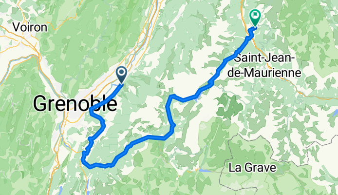
Overview
About this route
Camping le Bois Joli 73130 Saint Martin sur la Chambre (tel. 09 66 97 21 28)
- -:--
- Duration
- 107 km
- Distance
- 2,047 m
- Ascent
- 1,717 m
- Descent
- ---
- Avg. speed
- ---
- Max. altitude
Route quality
Waytypes & surfaces along the route
Waytypes
Road
4.3 km
(4 %)
Quiet road
4.3 km
(4 %)
Surfaces
Paved
65.3 km
(61 %)
Unpaved
1.1 km
(1 %)
Asphalt
65.3 km
(61 %)
Gravel
1.1 km
(1 %)
Undefined
40.7 km
(38 %)
Continue with Bikemap
Use, edit, or download this cycling route
You would like to ride Villard-Bonnot 1 or customize it for your own trip? Here is what you can do with this Bikemap route:
Free features
- Save this route as favorite or in collections
- Copy & plan your own version of this route
- Split it into stages to create a multi-day tour
- Sync your route with Garmin or Wahoo
Premium features
Free trial for 3 days, or one-time payment. More about Bikemap Premium.
- Navigate this route on iOS & Android
- Export a GPX / KML file of this route
- Create your custom printout (try it for free)
- Download this route for offline navigation
Discover more Premium features.
Get Bikemap PremiumFrom our community
Other popular routes starting in Villard-Bonnot
 Villard-Bonnot 1
- Distance
- 107 km
- Ascent
- 2,047 m
- Descent
- 1,717 m
- Location
- Villard-Bonnot, Auvergne-Rhône-Alpes, France
 43 Impasse du Grand Joly, Sainte-Agnès à 43 Impasse du Grand Joly, Sainte-Agnès
- Distance
- 32.7 km
- Ascent
- 1,135 m
- Descent
- 1,135 m
- Location
- Villard-Bonnot, Auvergne-Rhône-Alpes, France
 De Avenue des Papeteries 4, Villard-Bonnot à Avenue des Papeteries 4, Villard-Bonnot
- Distance
- 51.3 km
- Ascent
- 1,485 m
- Descent
- 1,485 m
- Location
- Villard-Bonnot, Auvergne-Rhône-Alpes, France
 Col de Pré Long
- Distance
- 12 km
- Ascent
- 999 m
- Descent
- 23 m
- Location
- Villard-Bonnot, Auvergne-Rhône-Alpes, France
 2385 Route du Col des Mouilles, Sainte-Agnès à 5 Sentier de la Bastille, Saint-Martin-le-Vinoux
- Distance
- 26.8 km
- Ascent
- 351 m
- Descent
- 788 m
- Location
- Villard-Bonnot, Auvergne-Rhône-Alpes, France
 Balcons de Belledonne
- Distance
- 82.5 km
- Ascent
- 1,776 m
- Descent
- 1,778 m
- Location
- Villard-Bonnot, Auvergne-Rhône-Alpes, France
 COL DES MOUILLES PAR VILLARD BONNOT
- Distance
- 9.8 km
- Ascent
- 778 m
- Descent
- 11 m
- Location
- Villard-Bonnot, Auvergne-Rhône-Alpes, France
 Quick bike tour through La-Combe-de-Lancey
- Distance
- 8.7 km
- Ascent
- 204 m
- Descent
- 207 m
- Location
- Villard-Bonnot, Auvergne-Rhône-Alpes, France
Open it in the app