
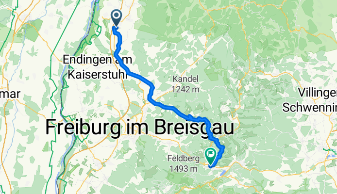
Ringsheim-Hinterzarten
A cycling route starting in Ringsheim, Baden-Wurttemberg, Germany.
Overview
About this route
3.Etappe meiner Schwarzwaldtour 2006
- -:--
- Duration
- 68 km
- Distance
- 1,161 m
- Ascent
- 448 m
- Descent
- ---
- Avg. speed
- ---
- Max. altitude
Route quality
Waytypes & surfaces along the route
Waytypes
Quiet road
26.5 km
(39 %)
Path
12.2 km
(18 %)
Surfaces
Paved
57.1 km
(84 %)
Unpaved
1.4 km
(2 %)
Asphalt
52.4 km
(77 %)
Paved (undefined)
4.8 km
(7 %)
Continue with Bikemap
Use, edit, or download this cycling route
You would like to ride Ringsheim-Hinterzarten or customize it for your own trip? Here is what you can do with this Bikemap route:
Free features
- Save this route as favorite or in collections
- Copy & plan your own version of this route
- Sync your route with Garmin or Wahoo
Premium features
Free trial for 3 days, or one-time payment. More about Bikemap Premium.
- Navigate this route on iOS & Android
- Export a GPX / KML file of this route
- Create your custom printout (try it for free)
- Download this route for offline navigation
Discover more Premium features.
Get Bikemap PremiumFrom our community
Other popular routes starting in Ringsheim
 00 Ringsheim - Europapark
- Distance
- 6.2 km
- Ascent
- 5 m
- Descent
- 12 m
- Location
- Ringsheim, Baden-Wurttemberg, Germany
 Mahlberger Straße 6, Ringsheim nach Straßburger Straße 18, Kehl
- Distance
- 44.5 km
- Ascent
- 213 m
- Descent
- 241 m
- Location
- Ringsheim, Baden-Wurttemberg, Germany
 Weisweil
- Distance
- 37.8 km
- Ascent
- 67 m
- Descent
- 65 m
- Location
- Ringsheim, Baden-Wurttemberg, Germany
 glotertal
- Distance
- 33.5 km
- Ascent
- 458 m
- Descent
- 337 m
- Location
- Ringsheim, Baden-Wurttemberg, Germany
 Höfle
Höfle- Distance
- 24.9 km
- Ascent
- 479 m
- Descent
- 478 m
- Location
- Ringsheim, Baden-Wurttemberg, Germany
 Ettenheim To Freiburg
- Distance
- 36.3 km
- Ascent
- 121 m
- Descent
- 14 m
- Location
- Ringsheim, Baden-Wurttemberg, Germany
 Flache Runde
- Distance
- 52.1 km
- Ascent
- 171 m
- Descent
- 169 m
- Location
- Ringsheim, Baden-Wurttemberg, Germany
 Alte Hauptstraße 29, Ringsheim nach Friedrichstraße 6, Ettenheim
- Distance
- 4.3 km
- Ascent
- 14 m
- Descent
- 54 m
- Location
- Ringsheim, Baden-Wurttemberg, Germany
Open it in the app