

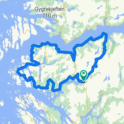
Rock cycling in Haugsdalen and Engleberget
A cycling route starting in Mo, Hordaland Fylke, Norway.
Overview
About this route
This is a tour with single track and some playgrounds for rock cycling.
Go to the end of the construcion road at Svartavanet in Haugsdalen valley. Bike, drive by car or hire lift from Matre, one hour north of Bergen. Turn downvards and take left. Follow a single track, andthen our own way in naure andon rock down to the road. Follow the road back 700m and tak left. Leave the road just before the bridge, and a playground of soft rock is in front of you. You can fllow both sides f theriver, but normally I cross the river short distanse under the bridge, and follow on the right hand side. Depentend of the level of water in the lake, you cross in the north side of the lake. If full it ismaybe easiest to climbup the hill. Normally you cntinue to a ne playground with soft rocks untill you reach the road. Follow the road 2 km south were it is possible to have a short tip to the left. Then 300m ahead leave the road again, and the playground at Engleberget i in front of you. Find your way on the rocks down to the lake. Follow on the left/east side around the lake. In the inner part you choose your own level of difficulty for playing. On the last part back to the road there are flat smooth rocks. Full susension bike is higly recomended. Hire: www.bergfritid.no <div style="left: -1000px; top: 105.2px; width: 1px; height: 1px; overflow: hidden; position: absolute;"> </div> <div style="left: -1000px; top: 441.2px; width: 1px; height: 1px; overflow: hidden; position: absolute;"> </div>
- -:--
- Duration
- 11.5 km
- Distance
- 557 m
- Ascent
- 694 m
- Descent
- ---
- Avg. speed
- ---
- Avg. speed

Continue with Bikemap
Use, edit, or download this cycling route
You would like to ride Rock cycling in Haugsdalen and Engleberget or customize it for your own trip? Here is what you can do with this Bikemap route:
Free features
- Save this route as favorite or in collections
- Copy & plan your own version of this route
- Sync your route with Garmin or Wahoo
Premium features
Free trial for 3 days, or one-time payment. More about Bikemap Premium.
- Navigate this route on iOS & Android
- Export a GPX / KML file of this route
- Create your custom printout (try it for free)
- Download this route for offline navigation
Discover more Premium features.
Get Bikemap PremiumFrom our community
Other popular routes starting in Mo
 Stølsheimen Vest: Fjordsykkelruta
- Distance
- 217.5 km
- Ascent
- 2,041 m
- Descent
- 2,041 m
- Location
- Mo, Hordaland Fylke, Norway
 Stordalen: Anleggsveien
- Distance
- 10.6 km
- Ascent
- 263 m
- Descent
- 348 m
- Location
- Mo, Hordaland Fylke, Norway
 BF1 Matresdalen
- Distance
- 4.8 km
- Ascent
- 759 m
- Descent
- 499 m
- Location
- Mo, Hordaland Fylke, Norway
 Stølsheimen Vest
- Distance
- 152.3 km
- Ascent
- 1,505 m
- Descent
- 1,504 m
- Location
- Mo, Hordaland Fylke, Norway
 BF7 Matre Slovag
- Distance
- 45.2 km
- Ascent
- 1,310 m
- Descent
- 1,690 m
- Location
- Mo, Hordaland Fylke, Norway
 BF3 Anleggsveien Stordalen
- Distance
- 10.6 km
- Ascent
- 355 m
- Descent
- 440 m
- Location
- Mo, Hordaland Fylke, Norway
 Stølsheimen Vest: Fjordsykkelruta
- Distance
- 217.5 km
- Ascent
- 1,751 m
- Descent
- 1,735 m
- Location
- Mo, Hordaland Fylke, Norway
 Rock cycling in Haugsdalen and Engleberget
- Distance
- 11.5 km
- Ascent
- 557 m
- Descent
- 694 m
- Location
- Mo, Hordaland Fylke, Norway
Open it in the app