2014_Kempten-Bolsena_07
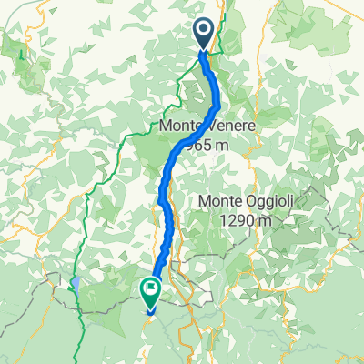
- 124.3 km
- 1,054 m
- 1,105 m
- Sasso Marconi, Emilia-Romagna, Italy
A cycling route starting in Sasso Marconi, Emilia-Romagna, Italy.
Overview
Start: Hotel Locanda 3 Virtu, Sasso Marconi
Ziel: Camping Area di Sosta, Florenz
created this 11 years ago
Route quality
Quiet road
38.5 km
(31 %)
Cycleway
14.9 km
(12 %)
Paved
89.5 km
(72 %)
Unpaved
6.2 km
(5 %)
Asphalt
89.5 km
(72 %)
Gravel
6.2 km
(5 %)
Undefined
28.6 km
(23 %)
Route highlights
Hotel Locanda 3 Virtù Via Ponte Albano, 97, Sasso Marconi, Bologna, Italy locanda3virtu.it 051 675 0182
Area di sosta - Camping Florenz Viale G. Dalla Chiesa, 1/3 - 50136 - FIRENZE Tel. +39 055 4698300 E-MAIL: campingfirenze@ecvacanze.it
Continue with Bikemap
You would like to ride 2014_Kempten-Bolsena_07 or customize it for your own trip? Here is what you can do with this Bikemap route:
Free trial for 3 days, or one-time payment. More about Bikemap Premium.
Discover more Premium features.
Get Bikemap PremiumFrom our community
Open it in the app