

A8 Ecke
A cycling route starting in Odelzhausen, Bavaria, Germany.
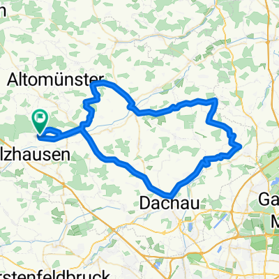
Overview
About this route
Lots of forest around the A8. Very beautiful forest paths with many hills, bridges, and pure nature.
- -:--
- Duration
- 19.7 km
- Distance
- 110 m
- Ascent
- 98 m
- Descent
- ---
- Avg. speed
- ---
- Max. altitude

Route quality
Waytypes & surfaces along the route
Waytypes
Track
15 km
(76 %)
Road
4.3 km
(22 %)
Quiet road
0.4 km
(2 %)
Surfaces
Paved
1.8 km
(9 %)
Unpaved
15 km
(76 %)
Gravel
11.6 km
(59 %)
Unpaved (undefined)
3.3 km
(17 %)
Continue with Bikemap
Use, edit, or download this cycling route
You would like to ride A8 Ecke or customize it for your own trip? Here is what you can do with this Bikemap route:
Free features
- Save this route as favorite or in collections
- Copy & plan your own version of this route
- Sync your route with Garmin or Wahoo
Premium features
Free trial for 3 days, or one-time payment. More about Bikemap Premium.
- Navigate this route on iOS & Android
- Export a GPX / KML file of this route
- Create your custom printout (try it for free)
- Download this route for offline navigation
Discover more Premium features.
Get Bikemap PremiumFrom our community
Other popular routes starting in Odelzhausen
 Radltour
- Distance
- 36.2 km
- Ascent
- 141 m
- Descent
- 141 m
- Location
- Odelzhausen, Bavaria, Germany
 A8 Ecke
- Distance
- 19.7 km
- Ascent
- 110 m
- Descent
- 98 m
- Location
- Odelzhausen, Bavaria, Germany
 Lange Radrunde vom 11. Juni, 12:39
- Distance
- 71 km
- Ascent
- 193 m
- Descent
- 191 m
- Location
- Odelzhausen, Bavaria, Germany
 Pucher Badesee
- Distance
- 16.5 km
- Ascent
- 63 m
- Descent
- 44 m
- Location
- Odelzhausen, Bavaria, Germany
 Taxa - Miegersbach - Tremmel - Brugger - Hohenzell - Sixnitgern - Geiselwies - Roßbach - Taxa
- Distance
- 20.9 km
- Ascent
- 64 m
- Descent
- 66 m
- Location
- Odelzhausen, Bavaria, Germany
 20170720_135927.gpx
- Distance
- 41 km
- Ascent
- 102 m
- Descent
- 93 m
- Location
- Odelzhausen, Bavaria, Germany
 Rundtour Richtung Westen
- Distance
- 22.2 km
- Ascent
- 172 m
- Descent
- 170 m
- Location
- Odelzhausen, Bavaria, Germany
 Aufnahme vom 22. Mai, 15:39 bis Akku leer
- Distance
- 44.7 km
- Ascent
- 169 m
- Descent
- 129 m
- Location
- Odelzhausen, Bavaria, Germany
Open it in the app