

Moto 13.06.2014
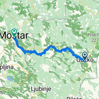
A cycling route starting in Gacko, Republika Srpska, Bosnia and Herzegovina.
Overview
About this route
Friday, 13.06.20144,200 - 4,123 = 77 km
- -:--
- Duration
- 80 km
- Distance
- 917 m
- Ascent
- 1,289 m
- Descent
- ---
- Avg. speed
- ---
- Max. altitude

Continue with Bikemap
Use, edit, or download this cycling route
You would like to ride Moto 13.06.2014 or customize it for your own trip? Here is what you can do with this Bikemap route:
Free features
- Save this route as favorite or in collections
- Copy & plan your own version of this route
- Split it into stages to create a multi-day tour
- Sync your route with Garmin or Wahoo
Premium features
Free trial for 3 days, or one-time payment. More about Bikemap Premium.
- Navigate this route on iOS & Android
- Export a GPX / KML file of this route
- Create your custom printout (try it for free)
- Download this route for offline navigation
Discover more Premium features.
Get Bikemap PremiumFrom our community
Other popular routes starting in Gacko
 BiH Dramešina-Ravna Greda
- Distance
- 15.2 km
- Ascent
- 653 m
- Descent
- 494 m
- Location
- Gacko, Republika Srpska, Bosnia and Herzegovina
 Gacko nach Mostar
- Distance
- 91.4 km
- Ascent
- 1,050 m
- Descent
- 1,940 m
- Location
- Gacko, Republika Srpska, Bosnia and Herzegovina
 Klinje Lake nach Mostar
- Distance
- 97.6 km
- Ascent
- 600 m
- Descent
- 1,607 m
- Location
- Gacko, Republika Srpska, Bosnia and Herzegovina
 Volujak - Velika Vlasulja
- Distance
- 15.5 km
- Ascent
- 1,688 m
- Descent
- 160 m
- Location
- Gacko, Republika Srpska, Bosnia and Herzegovina
 BiH 8, Čemerno Zelengora Orlovačko Jezero Lelija Kalinovo
- Distance
- 49.5 km
- Ascent
- 920 m
- Descent
- 1,128 m
- Location
- Gacko, Republika Srpska, Bosnia and Herzegovina
 donje bare - tjentiste
- Distance
- 66 km
- Ascent
- 1,416 m
- Descent
- 2,362 m
- Location
- Gacko, Republika Srpska, Bosnia and Herzegovina
 Dzień 4: Klinje - Stari Dud
- Distance
- 55.5 km
- Ascent
- 1,097 m
- Descent
- 1,743 m
- Location
- Gacko, Republika Srpska, Bosnia and Herzegovina
 Čemerno - Tjentiště
- Distance
- 40.5 km
- Ascent
- 560 m
- Descent
- 1,329 m
- Location
- Gacko, Republika Srpska, Bosnia and Herzegovina
Open it in the app