

Glacier-Waterton Loop D3
A cycling route starting in Fernie, British Columbia, Canada.
Overview
About this route
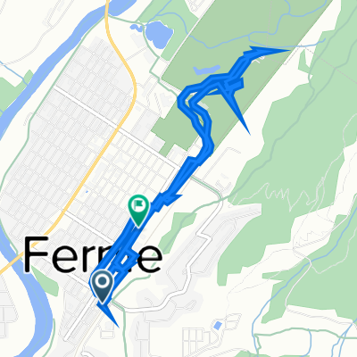
Glacier-Waterton Loop Day 3
Fernie - Blairmore (Lost Lemon RV Park)
- -:--
- Duration
- 68.7 km
- Distance
- 622 m
- Ascent
- 265 m
- Descent
- ---
- Avg. speed
- 1,382 m
- Max. altitude
Route quality
Waytypes & surfaces along the route
Waytypes
Cycleway
48.1 km
(70 %)
Quiet road
13.1 km
(19 %)
Surfaces
Paved
22 km
(32 %)
Unpaved
5.5 km
(8 %)
Paved (undefined)
16.5 km
(24 %)
Asphalt
5.5 km
(8 %)
Continue with Bikemap
Use, edit, or download this cycling route
You would like to ride Glacier-Waterton Loop D3 or customize it for your own trip? Here is what you can do with this Bikemap route:
Free features
- Save this route as favorite or in collections
- Copy & plan your own version of this route
- Sync your route with Garmin or Wahoo
Premium features
Free trial for 3 days, or one-time payment. More about Bikemap Premium.
- Navigate this route on iOS & Android
- Export a GPX / KML file of this route
- Create your custom printout (try it for free)
- Download this route for offline navigation
Discover more Premium features.
Get Bikemap PremiumFrom our community
Other popular routes starting in Fernie
 Canada Day 17: Fernie to Cranbrook
- Distance
- 97.1 km
- Ascent
- 386 m
- Descent
- 461 m
- Location
- Fernie, British Columbia, Canada
 Fernie Cycling
- Distance
- 19.5 km
- Ascent
- 461 m
- Descent
- 434 m
- Location
- Fernie, British Columbia, Canada
 Fernie to Gray Creek
- Distance
- 198.7 km
- Ascent
- 1,630 m
- Descent
- 2,055 m
- Location
- Fernie, British Columbia, Canada
 341 First Ave, Fernie to 802 Second Ave, Fernie
- Distance
- 6.7 km
- Ascent
- 1,293 m
- Descent
- 1,293 m
- Location
- Fernie, British Columbia, Canada
 Broadwood loop
- Distance
- 76.7 km
- Ascent
- 705 m
- Descent
- 705 m
- Location
- Fernie, British Columbia, Canada
 Fernie to Gray Creek
- Distance
- 209.8 km
- Ascent
- 2,042 m
- Descent
- 2,467 m
- Location
- Fernie, British Columbia, Canada
 Hartley Lake Road to Bull River and return on Galloway and River/Cokato
- Distance
- 126.2 km
- Ascent
- 948 m
- Descent
- 947 m
- Location
- Fernie, British Columbia, Canada
 Fernie-Cranbrook
- Distance
- 106.1 km
- Ascent
- 399 m
- Descent
- 496 m
- Location
- Fernie, British Columbia, Canada
Open it in the app