

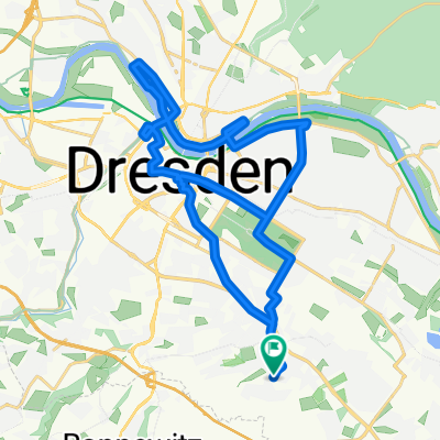
Berg und Tal vorm Abendmal
A cycling route starting in Bannewitz, Saxony, Germany.
Overview
About this route
<p>The route is:</p>
<p>- Suitable for mountain biking and partially for cyclo-cross</p>
<p>- Featuring beautiful terrain descents</p>
<p>- Sprinkled with nearly impossible climbs</p>
<p>- At times, a nice bypass of the B172</p>
Translated, show original (German)- -:--
- Duration
- 39.5 km
- Distance
- 495 m
- Ascent
- 595 m
- Descent
- ---
- Avg. speed
- ---
- Max. altitude
Continue with Bikemap
Use, edit, or download this cycling route
You would like to ride Berg und Tal vorm Abendmal or customize it for your own trip? Here is what you can do with this Bikemap route:
Free features
- Save this route as favorite or in collections
- Copy & plan your own version of this route
- Sync your route with Garmin or Wahoo
Premium features
Free trial for 3 days, or one-time payment. More about Bikemap Premium.
- Navigate this route on iOS & Android
- Export a GPX / KML file of this route
- Create your custom printout (try it for free)
- Download this route for offline navigation
Discover more Premium features.
Get Bikemap PremiumFrom our community
Other popular routes starting in Bannewitz
 RundumTour Bannewitz 2025
- Distance
- 31.6 km
- Ascent
- 447 m
- Descent
- 446 m
- Location
- Bannewitz, Saxony, Germany
 Vonovia-Tour
- Distance
- 28.8 km
- Ascent
- 121 m
- Descent
- 121 m
- Location
- Bannewitz, Saxony, Germany
 Etapa 046C (Dresden - Děčín)
- Distance
- 91.8 km
- Ascent
- 869 m
- Descent
- 860 m
- Location
- Bannewitz, Saxony, Germany
 Bannewitz - Klingenberg - Malter - Bannewitz
- Distance
- 67.7 km
- Ascent
- 779 m
- Descent
- 727 m
- Location
- Bannewitz, Saxony, Germany
 kleine Sonntagsrunde
- Distance
- 23 km
- Ascent
- 337 m
- Descent
- 245 m
- Location
- Bannewitz, Saxony, Germany
 Die Autobahntour: 34 km Hügel im Dresdner Süden
- Distance
- 33.9 km
- Ascent
- 549 m
- Descent
- 548 m
- Location
- Bannewitz, Saxony, Germany
 Radtour Elberadweg
- Distance
- 30.6 km
- Ascent
- 26 m
- Descent
- 32 m
- Location
- Bannewitz, Saxony, Germany
 Windberg-Poisenwald-Tharandt
- Distance
- 47.2 km
- Ascent
- 865 m
- Descent
- 865 m
- Location
- Bannewitz, Saxony, Germany
Open it in the app