

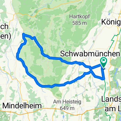
98 km Über Kaltental
A cycling route starting in Obermeitingen, Bavaria, Germany.
Overview
About this route
Über Igling,Hohensolgen,Oberostendorf,Schwabbruck,
Hohenfurch zurück nach Obermeitingen- -:--
- Duration
- 97.6 km
- Distance
- 348 m
- Ascent
- 348 m
- Descent
- ---
- Avg. speed
- ---
- Max. altitude
Route quality
Waytypes & surfaces along the route
Waytypes
Road
36.5 km
(37 %)
Busy road
27.7 km
(28 %)
Surfaces
Paved
92.7 km
(95 %)
Unpaved
2 km
(2 %)
Asphalt
92.4 km
(95 %)
Gravel
1.6 km
(2 %)
Continue with Bikemap
Use, edit, or download this cycling route
You would like to ride 98 km Über Kaltental or customize it for your own trip? Here is what you can do with this Bikemap route:
Free features
- Save this route as favorite or in collections
- Copy & plan your own version of this route
- Split it into stages to create a multi-day tour
- Sync your route with Garmin or Wahoo
Premium features
Free trial for 3 days, or one-time payment. More about Bikemap Premium.
- Navigate this route on iOS & Android
- Export a GPX / KML file of this route
- Create your custom printout (try it for free)
- Download this route for offline navigation
Discover more Premium features.
Get Bikemap PremiumFrom our community
Other popular routes starting in Obermeitingen
 Obermeitingen/Auerberg/Hohenpeißenberg/Obermeitingen
- Distance
- 146.2 km
- Ascent
- 763 m
- Descent
- 760 m
- Location
- Obermeitingen, Bavaria, Germany
 Zu den Störchen in Pfaffenhausen
- Distance
- 83.4 km
- Ascent
- 265 m
- Descent
- 262 m
- Location
- Obermeitingen, Bavaria, Germany
 Radrunde durch Obermeitingen
- Distance
- 14.5 km
- Ascent
- 16 m
- Descent
- 15 m
- Location
- Obermeitingen, Bavaria, Germany
 Sonntags Tour
- Distance
- 30.4 km
- Ascent
- 86 m
- Descent
- 92 m
- Location
- Obermeitingen, Bavaria, Germany
 Igling/Denklingen/Hohenp./Peiting/Schongau/Epfach/Obermeitingen
- Distance
- 120.3 km
- Ascent
- 631 m
- Descent
- 626 m
- Location
- Obermeitingen, Bavaria, Germany
 Stauden 76km
- Distance
- 76.7 km
- Ascent
- 311 m
- Descent
- 312 m
- Location
- Obermeitingen, Bavaria, Germany
 98 km Über Kaltental
- Distance
- 97.6 km
- Ascent
- 348 m
- Descent
- 348 m
- Location
- Obermeitingen, Bavaria, Germany
 Radtour 127,6 km
- Distance
- 127.5 km
- Ascent
- 478 m
- Descent
- 477 m
- Location
- Obermeitingen, Bavaria, Germany
Open it in the app