

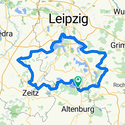
Haselb.-Wyhra-Eschefeld-Windischleuba
A cycling route starting in Haselbach, Thuringia, Germany.
Overview
About this route
Haselbach, Treben, Wyhra, Eschefeld, Dolsenhain, Pöppschen, Windischleuba
- -:--
- Duration
- 25.7 km
- Distance
- 110 m
- Ascent
- 104 m
- Descent
- ---
- Avg. speed
- ---
- Max. altitude
Route quality
Waytypes & surfaces along the route
Waytypes
Road
4.6 km
(18 %)
Track
4.4 km
(17 %)
Surfaces
Paved
17.2 km
(67 %)
Unpaved
0.5 km
(2 %)
Asphalt
12.8 km
(50 %)
Paved (undefined)
4.4 km
(17 %)
Continue with Bikemap
Use, edit, or download this cycling route
You would like to ride Haselb.-Wyhra-Eschefeld-Windischleuba or customize it for your own trip? Here is what you can do with this Bikemap route:
Free features
- Save this route as favorite or in collections
- Copy & plan your own version of this route
- Sync your route with Garmin or Wahoo
Premium features
Free trial for 3 days, or one-time payment. More about Bikemap Premium.
- Navigate this route on iOS & Android
- Export a GPX / KML file of this route
- Create your custom printout (try it for free)
- Download this route for offline navigation
Discover more Premium features.
Get Bikemap PremiumFrom our community
Other popular routes starting in Haselbach
 Hohenmölsen - Markkleeberg - Bad Lausick
- Distance
- 139.7 km
- Ascent
- 241 m
- Descent
- 243 m
- Location
- Haselbach, Thuringia, Germany
 Haselbacher See - Lucka
- Distance
- 19.4 km
- Ascent
- 84 m
- Descent
- 61 m
- Location
- Haselbach, Thuringia, Germany
 Haselb.-Wyhra-Eschefeld-Windischleuba
- Distance
- 25.7 km
- Ascent
- 110 m
- Descent
- 104 m
- Location
- Haselbach, Thuringia, Germany
 Teichwolframsdorf
- Distance
- 110.6 km
- Ascent
- 427 m
- Descent
- 427 m
- Location
- Haselbach, Thuringia, Germany
 Frohburg-Waldenburg-Leinawald
- Distance
- 101.9 km
- Ascent
- 537 m
- Descent
- 535 m
- Location
- Haselbach, Thuringia, Germany
 Pleißental und Leinawald
- Distance
- 44 km
- Ascent
- 164 m
- Descent
- 162 m
- Location
- Haselbach, Thuringia, Germany
 Frohburg-Prießnitz-Thräna
- Distance
- 45 km
- Ascent
- 176 m
- Descent
- 174 m
- Location
- Haselbach, Thuringia, Germany
 Haselbacher See - Lucka - Großstolpen
- Distance
- 40.8 km
- Ascent
- 123 m
- Descent
- 123 m
- Location
- Haselbach, Thuringia, Germany
Open it in the app