

CC POHR trainer
A cycling route starting in Brecksville, Ohio, United States.
Overview
About this route
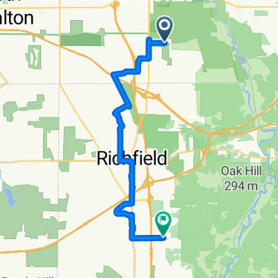
Start at the Station Road parking. Rolling hills at the start and a "decently" paved Brecksville road. A "woohoo" ride back down to the valley, very yummy farm market and 3/4 loop around the CVNP floor. Back up out of the valley through the Kendall lake area and either olde 8 or the Bike and Hike trail to get us back to Highland -past Brandywine ski complete the loop.
As listed about 40 miles. This route avaids the construction on Riverview for July 2014.- -:--
- Duration
- 66.7 km
- Distance
- 435 m
- Ascent
- 434 m
- Descent
- ---
- Avg. speed
- ---
- Max. altitude

Route quality
Waytypes & surfaces along the route
Waytypes
Road
41.4 km
(62 %)
Quiet road
7.3 km
(11 %)
Surfaces
Paved
24.7 km
(37 %)
Asphalt
24.7 km
(37 %)
Undefined
42 km
(63 %)
Continue with Bikemap
Use, edit, or download this cycling route
You would like to ride CC POHR trainer or customize it for your own trip? Here is what you can do with this Bikemap route:
Free features
- Save this route as favorite or in collections
- Copy & plan your own version of this route
- Sync your route with Garmin or Wahoo
Premium features
Free trial for 3 days, or one-time payment. More about Bikemap Premium.
- Navigate this route on iOS & Android
- Export a GPX / KML file of this route
- Create your custom printout (try it for free)
- Download this route for offline navigation
Discover more Premium features.
Get Bikemap PremiumFrom our community
Other popular routes starting in Brecksville
 17.7 km from home
- Distance
- 17.7 km
- Ascent
- 234 m
- Descent
- 220 m
- Location
- Brecksville, Ohio, United States
 From Brecksville to Akron
- Distance
- 18.9 km
- Ascent
- 197 m
- Descent
- 160 m
- Location
- Brecksville, Ohio, United States
 7776 Chaffee Rd, Northfield to 5017 Great Oaks Pkwy, Independence
- Distance
- 37.2 km
- Ascent
- 741 m
- Descent
- 673 m
- Location
- Brecksville, Ohio, United States
 Towpath Trail, Northfield to SR-8 S, Hudson
- Distance
- 28.5 km
- Ascent
- 281 m
- Descent
- 169 m
- Location
- Brecksville, Ohio, United States
 CC POHR trainer
- Distance
- 66.7 km
- Ascent
- 435 m
- Descent
- 434 m
- Location
- Brecksville, Ohio, United States
 5-17-15
- Distance
- 23.8 km
- Ascent
- 69 m
- Descent
- 67 m
- Location
- Brecksville, Ohio, United States
 walk - deer lick cave loop
- Distance
- 6.7 km
- Ascent
- 168 m
- Descent
- 166 m
- Location
- Brecksville, Ohio, United States
 Valley trainer July 2014
- Distance
- 25.5 km
- Ascent
- 279 m
- Descent
- 259 m
- Location
- Brecksville, Ohio, United States
Open it in the app