

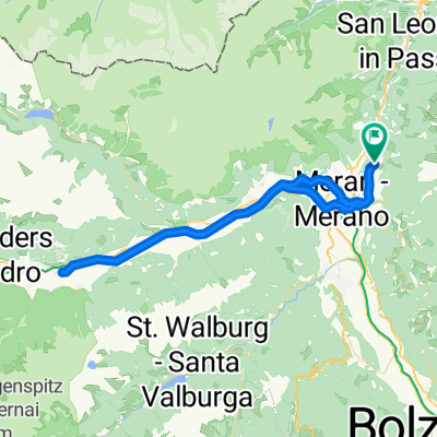
Oberschererhof, Marling - Schenna
A cycling route starting in Scena - Schenna, Trentino-Alto Adige, Italy.
Overview
About this route
Marling naar Schenna
- -:--
- Duration
- 10.7 km
- Distance
- 13 m
- Ascent
- 337 m
- Descent
- ---
- Avg. speed
- ---
- Max. altitude

Route quality
Waytypes & surfaces along the route
Waytypes
Road
4.8 km
(45 %)
Cycleway
1.2 km
(11 %)
Surfaces
Paved
10.6 km
(99 %)
Asphalt
10.6 km
(99 %)
Undefined
0.1 km
(1 %)
Continue with Bikemap
Use, edit, or download this cycling route
You would like to ride Oberschererhof, Marling - Schenna or customize it for your own trip? Here is what you can do with this Bikemap route:
Free features
- Save this route as favorite or in collections
- Copy & plan your own version of this route
- Sync your route with Garmin or Wahoo
Premium features
Free trial for 3 days, or one-time payment. More about Bikemap Premium.
- Navigate this route on iOS & Android
- Export a GPX / KML file of this route
- Create your custom printout (try it for free)
- Download this route for offline navigation
Discover more Premium features.
Get Bikemap PremiumFrom our community
Other popular routes starting in Scena - Schenna
 Schenna Latsch
- Distance
- 66.7 km
- Ascent
- 730 m
- Descent
- 733 m
- Location
- Scena - Schenna, Trentino-Alto Adige, Italy
 Taserbahn Meran 2000
- Distance
- 4.2 km
- Ascent
- 40 m
- Descent
- 207 m
- Location
- Scena - Schenna, Trentino-Alto Adige, Italy
 Oberschererhof, Marling - Schenna
- Distance
- 10.7 km
- Ascent
- 13 m
- Descent
- 337 m
- Location
- Scena - Schenna, Trentino-Alto Adige, Italy
 Schenna - Hirzer und Taser Abfahrt
- Distance
- 26.7 km
- Ascent
- 1,862 m
- Descent
- 1,862 m
- Location
- Scena - Schenna, Trentino-Alto Adige, Italy
 Kuens nach Dia Dalade Campenstraße, Marling
- Distance
- 31.6 km
- Ascent
- 722 m
- Descent
- 796 m
- Location
- Scena - Schenna, Trentino-Alto Adige, Italy
 Schenna - Taserhöhenweg u.z.
- Distance
- 28.1 km
- Ascent
- 1,414 m
- Descent
- 1,414 m
- Location
- Scena - Schenna, Trentino-Alto Adige, Italy
 schenna MTB
- Distance
- 37.4 km
- Ascent
- 1,340 m
- Descent
- 1,356 m
- Location
- Scena - Schenna, Trentino-Alto Adige, Italy
 Rothtalerweg, Schenna nach Dorfweg, Hafling
- Distance
- 12.3 km
- Ascent
- 3,041 m
- Descent
- 2,334 m
- Location
- Scena - Schenna, Trentino-Alto Adige, Italy
Open it in the app