

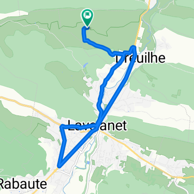
Lavelanet-Boucle 120Km
A cycling route starting in Lavelanet, Occitanie, France.
Overview
About this route
Lavelanet-Oust via D10 then north. Passage through Aude (Belbech) - East via D25 / D102 (Ribouisse). South via D6/D6A - Malgoude - Moulin neuf - Trézirs - Camon - Sonac - Chalabre - Lac de Montbel - D28A - D16 - D620 - Bastide-sur-L'Hers - D16 - Lesparou - L'aiguillon - D117 - St Jean-d'Aigues-Vives - Lavelanet. 120 Km
- -:--
- Duration
- 120.3 km
- Distance
- 617 m
- Ascent
- 617 m
- Descent
- ---
- Avg. speed
- ---
- Max. altitude
Route quality
Waytypes & surfaces along the route
Waytypes
Road
43.3 km
(36 %)
Quiet road
7.2 km
(6 %)
Surfaces
Paved
18 km
(15 %)
Unpaved
3.6 km
(3 %)
Asphalt
18 km
(15 %)
Gravel
3.6 km
(3 %)
Undefined
98.7 km
(82 %)
Continue with Bikemap
Use, edit, or download this cycling route
You would like to ride Lavelanet-Boucle 120Km or customize it for your own trip? Here is what you can do with this Bikemap route:
Free features
- Save this route as favorite or in collections
- Copy & plan your own version of this route
- Split it into stages to create a multi-day tour
- Sync your route with Garmin or Wahoo
Premium features
Free trial for 3 days, or one-time payment. More about Bikemap Premium.
- Navigate this route on iOS & Android
- Export a GPX / KML file of this route
- Create your custom printout (try it for free)
- Download this route for offline navigation
Discover more Premium features.
Get Bikemap PremiumFrom our community
Other popular routes starting in Lavelanet
 Balade 25/06/11
- Distance
- 10 km
- Ascent
- 187 m
- Descent
- 187 m
- Location
- Lavelanet, Occitanie, France
 Lavelanet - Puigserdà
- Distance
- 109.4 km
- Ascent
- 1,795 m
- Descent
- 1,115 m
- Location
- Lavelanet, Occitanie, France
 Etape 5 : Levelanet - Ax-Les-Thermes via Montsegur
- Distance
- 74.7 km
- Ascent
- 2,473 m
- Descent
- 2,273 m
- Location
- Lavelanet, Occitanie, France
 Pyrenäen 2000 Etappe 15
- Distance
- 87 km
- Ascent
- 1,042 m
- Descent
- 1,416 m
- Location
- Lavelanet, Occitanie, France
 F/Villeneuve-Espezel-Montsegur-ret
- Distance
- 88.1 km
- Ascent
- 1,292 m
- Descent
- 1,293 m
- Location
- Lavelanet, Occitanie, France
 Lavelanet-Boucle 120Km
- Distance
- 120.3 km
- Ascent
- 617 m
- Descent
- 617 m
- Location
- Lavelanet, Occitanie, France
 Montsegur a Brindisi
- Distance
- 3,190.5 km
- Ascent
- 7,935 m
- Descent
- 8,840 m
- Location
- Lavelanet, Occitanie, France
 ddsdq
ddsdq- Distance
- 20 km
- Ascent
- 186 m
- Descent
- 255 m
- Location
- Lavelanet, Occitanie, France
Open it in the app