

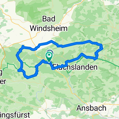
Oberdachstetten - Aub
A cycling route starting in Oberdachstetten, Bavaria, Germany.
Overview
About this route
Oberdachstetten - Karrach - Rothenburg - Biberehren - Aub
- -:--
- Duration
- 54.3 km
- Distance
- 322 m
- Ascent
- 470 m
- Descent
- ---
- Avg. speed
- ---
- Max. altitude
Route quality
Waytypes & surfaces along the route
Waytypes
Track
29 km
(53 %)
Quiet road
8.7 km
(16 %)
Surfaces
Paved
33.9 km
(62 %)
Unpaved
16 km
(29 %)
Asphalt
32.7 km
(60 %)
Unpaved (undefined)
9.9 km
(18 %)
Continue with Bikemap
Use, edit, or download this cycling route
You would like to ride Oberdachstetten - Aub or customize it for your own trip? Here is what you can do with this Bikemap route:
Free features
- Save this route as favorite or in collections
- Copy & plan your own version of this route
- Sync your route with Garmin or Wahoo
Premium features
Free trial for 3 days, or one-time payment. More about Bikemap Premium.
- Navigate this route on iOS & Android
- Export a GPX / KML file of this route
- Create your custom printout (try it for free)
- Download this route for offline navigation
Discover more Premium features.
Get Bikemap PremiumFrom our community
Other popular routes starting in Oberdachstetten
 Pivion 2012
- Distance
- 204.9 km
- Ascent
- 487 m
- Descent
- 487 m
- Location
- Oberdachstetten, Bavaria, Germany
 Bibert/Wildbad
- Distance
- 68.8 km
- Ascent
- 412 m
- Descent
- 410 m
- Location
- Oberdachstetten, Bavaria, Germany
 Von Oberdachstetten nach Colmberg und zurück
- Distance
- 38.9 km
- Ascent
- 260 m
- Descent
- 258 m
- Location
- Oberdachstetten, Bavaria, Germany
 Oberdachstetten Ipsheim Oberdachstetten
- Distance
- 46.6 km
- Ascent
- 433 m
- Descent
- 433 m
- Location
- Oberdachstetten, Bavaria, Germany
 Oberdachstetten - Aub
- Distance
- 54.3 km
- Ascent
- 322 m
- Descent
- 470 m
- Location
- Oberdachstetten, Bavaria, Germany
 Oberdachstetten - Burg Hoheneck - Ipsheim
- Distance
- 28 km
- Ascent
- 259 m
- Descent
- 394 m
- Location
- Oberdachstetten, Bavaria, Germany
 Oberdachstetten - Würzburg (Rennrad) Tour 2
- Distance
- 86.2 km
- Ascent
- 249 m
- Descent
- 519 m
- Location
- Oberdachstetten, Bavaria, Germany
 Straßenhof 3, Obernzenn nach Straßenhof 3, Obernzenn
- Distance
- 26.7 km
- Ascent
- 247 m
- Descent
- 247 m
- Location
- Oberdachstetten, Bavaria, Germany
Open it in the app