
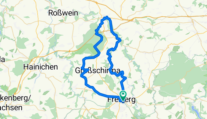
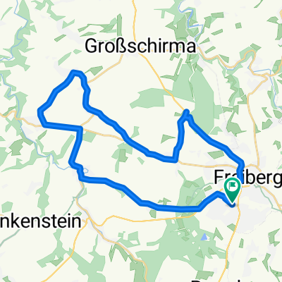
Freiberg Nossen
A cycling route starting in Freiberg, Saxony, Germany.
Overview
About this route
Recommended for Mountainbike and Crossbike
Many nice information along the way.
The route is composed of approx.
45% road
45% forest path
10% meadows and gravel
Many climbs and descents, especially from Nossen towards Freiberg
Starting centrally in Freiberg, you go by road to Halsbrücke then continue along the Freiberger Mulde (Muldenstraße) until a wooden bridge. Stay on the right bank and take a field path that has a steep ascent (push?). The path becomes a meadow path until you hit a straight field path. This leads to Hohentanne. There look for the Muldenweg and turn, until a sharp right bend. Then go straight/a little right onto a field path that leads directly to the Mulde.
Take the next bridge and you will be in Kleinvoigtsberg. At the end of the street, turn right. From there, there is a red path marked with a bike symbol. Follow it. At the next main road turn left and immediately right again.
At some point you will see the highway bridge of the A4. Just before the bridge, go right over the river and continue along the river until you arrive in Nossen. In Nossen, ride up to the castle, and then continue towards Freiberg. Follow the B101 to Netto and at the same height turn right into Zellsteig. Ride into Zellwald. After the highway underpass, turn left onto Forsthofweg. Leave this path soon by going straight onto a forest path. Follow this path for a long time (last stretch long hilly straight) until a railroad crossing. At the next opportunity turn 90° left into Graben 9. After the forest, turn briefly right onto the B101 and then immediately right again onto Zellwaldring towards Reichenbach. In Reichenbach turn left towards Seifersdorf. In Seifersdorf turn left towards Großschirma and at a historical directional sign (left side of the road) turn right towards Langenhennersdorf (field path). In Langenhennersdorf turn left at the church and at the next possible street turn right down the hill. At the main road, turn left and go all the way to the end. (Towards Kleinwaltersdorf). Go straight on Haunichener Straße towards Kleinwaltersdorf and then always along the road and you will be back in Freiberg.
Enjoy!
- -:--
- Duration
- 58 km
- Distance
- 398 m
- Ascent
- 398 m
- Descent
- ---
- Avg. speed
- ---
- Max. altitude
Continue with Bikemap
Use, edit, or download this cycling route
You would like to ride Freiberg Nossen or customize it for your own trip? Here is what you can do with this Bikemap route:
Free features
- Save this route as favorite or in collections
- Copy & plan your own version of this route
- Sync your route with Garmin or Wahoo
Premium features
Free trial for 3 days, or one-time payment. More about Bikemap Premium.
- Navigate this route on iOS & Android
- Export a GPX / KML file of this route
- Create your custom printout (try it for free)
- Download this route for offline navigation
Discover more Premium features.
Get Bikemap PremiumFrom our community
Other popular routes starting in Freiberg
 Freiberg-Niederschöna-Mulde-Münzbachtal
- Distance
- 29.4 km
- Ascent
- 366 m
- Descent
- 384 m
- Location
- Freiberg, Saxony, Germany
 FG-Mulda über Bernhardshöhe 1,5h
- Distance
- 32.1 km
- Ascent
- 372 m
- Descent
- 370 m
- Location
- Freiberg, Saxony, Germany
 Route003c-21.08.2025
- Distance
- 28.8 km
- Ascent
- 499 m
- Descent
- 502 m
- Location
- Freiberg, Saxony, Germany
 morgendliche kurzrunde
- Distance
- 16.5 km
- Ascent
- 176 m
- Descent
- 175 m
- Location
- Freiberg, Saxony, Germany
 Bü 35km Falkb-Hetzd-Tarantw-Grillenb-BhfKlingb
- Distance
- 35.3 km
- Ascent
- 499 m
- Descent
- 499 m
- Location
- Freiberg, Saxony, Germany
 FG-DW-202506
- Distance
- 31 km
- Ascent
- 472 m
- Descent
- 543 m
- Location
- Freiberg, Saxony, Germany
 "Mal kurz in den Tharandter-Wald und zurück"
- Distance
- 76.8 km
- Ascent
- 716 m
- Descent
- 716 m
- Location
- Freiberg, Saxony, Germany
 FG-DW-2507
- Distance
- 31.9 km
- Ascent
- 532 m
- Descent
- 602 m
- Location
- Freiberg, Saxony, Germany
Open it in the app