
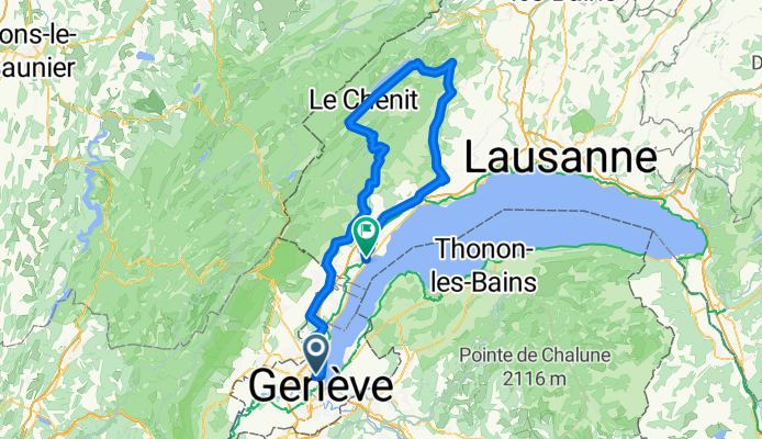
GVA - Marchairuz - Mollendruz - Nyon (test)
A cycling route starting in Le Grand-Saconnex, Canton of Geneva, Switzerland.
Overview
About this route
GVA - Marchairuz - Mollendruz - Nyon (test)
(cloned from route 2698541)- -:--
- Duration
- 122.6 km
- Distance
- 1,412 m
- Ascent
- 1,426 m
- Descent
- ---
- Avg. speed
- ---
- Max. altitude

Route quality
Waytypes & surfaces along the route
Waytypes
Road
70.4 km
(57 %)
Busy road
44.6 km
(36 %)
Surfaces
Paved
57.7 km
(47 %)
Asphalt
55.7 km
(45 %)
Paved (undefined)
1.9 km
(2 %)
Continue with Bikemap
Use, edit, or download this cycling route
You would like to ride GVA - Marchairuz - Mollendruz - Nyon (test) or customize it for your own trip? Here is what you can do with this Bikemap route:
Free features
- Save this route as favorite or in collections
- Copy & plan your own version of this route
- Split it into stages to create a multi-day tour
- Sync your route with Garmin or Wahoo
Premium features
Free trial for 3 days, or one-time payment. More about Bikemap Premium.
- Navigate this route on iOS & Android
- Export a GPX / KML file of this route
- Create your custom printout (try it for free)
- Download this route for offline navigation
Discover more Premium features.
Get Bikemap PremiumFrom our community
Other popular routes starting in Le Grand-Saconnex
 Petit Saconnex - Bellevue
- Distance
- 17.2 km
- Ascent
- 142 m
- Descent
- 144 m
- Location
- Le Grand-Saconnex, Canton of Geneva, Switzerland
 Col du Marchairuz (Road)
- Distance
- 106.6 km
- Ascent
- 1,560 m
- Descent
- 1,533 m
- Location
- Le Grand-Saconnex, Canton of Geneva, Switzerland
 Geneva Lake Cycling Test Run
- Distance
- 90.5 km
- Ascent
- 164 m
- Descent
- 197 m
- Location
- Le Grand-Saconnex, Canton of Geneva, Switzerland
 Contreforts du Jura
- Distance
- 51.8 km
- Ascent
- 729 m
- Descent
- 734 m
- Location
- Le Grand-Saconnex, Canton of Geneva, Switzerland
 G2N D1 Base route
- Distance
- 93.7 km
- Ascent
- 981 m
- Descent
- 1,087 m
- Location
- Le Grand-Saconnex, Canton of Geneva, Switzerland
 Genève - St-Cergue - Signal de Bougy
- Distance
- 103.3 km
- Ascent
- 1,025 m
- Descent
- 1,026 m
- Location
- Le Grand-Saconnex, Canton of Geneva, Switzerland
 Tour de Saleve
- Distance
- 70.5 km
- Ascent
- 1,286 m
- Descent
- 1,287 m
- Location
- Le Grand-Saconnex, Canton of Geneva, Switzerland
 BarcelonaTrip2010
- Distance
- 763.9 km
- Ascent
- 3,464 m
- Descent
- 3,826 m
- Location
- Le Grand-Saconnex, Canton of Geneva, Switzerland
Open it in the app