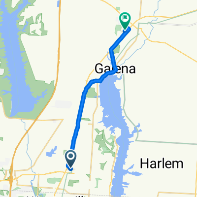
Red Bank +threshold
A cycling route starting in Westerville, Ohio, United States of America.
Overview
About this route
Westerville route, mostly flat except red bank hill
- -:--
- Duration
- 45.1 km
- Distance
- 119 m
- Ascent
- 119 m
- Descent
- ---
- Avg. speed
- ---
- Avg. speed
Route quality
Waytypes & surfaces along the route
Waytypes
Road
19.7 km
(44 %)
Quiet road
12.1 km
(27 %)
Surfaces
Paved
10.3 km
(23 %)
Asphalt
10.3 km
(23 %)
Concrete
0 km
(<1 %)
Undefined
34.7 km
(77 %)
Continue with Bikemap
Use, edit, or download this cycling route
You would like to ride Red Bank +threshold or customize it for your own trip? Here is what you can do with this Bikemap route:
Free features
- Save this route as favorite or in collections
- Copy & plan your own version of this route
- Sync your route with Garmin or Wahoo
Premium features
Free trial for 3 days, or one-time payment. More about Bikemap Premium.
- Navigate this route on iOS & Android
- Export a GPX / KML file of this route
- Create your custom printout (try it for free)
- Download this route for offline navigation
Discover more Premium features.
Get Bikemap PremiumFrom our community
Other popular routes starting in Westerville
- Westerville Bikes N Brews Tour
- Distance
- 13.8 km
- Ascent
- 50 m
- Descent
- 51 m
- Location
- Westerville, Ohio, United States of America
- From home to Galena Ohio
- Distance
- 7.3 km
- Ascent
- 31 m
- Descent
- 14 m
- Location
- Westerville, Ohio, United States of America
- Red Bank +threshold
- Distance
- 45.1 km
- Ascent
- 119 m
- Descent
- 119 m
- Location
- Westerville, Ohio, United States of America
- Westerville Bikes n Brews Tour Part II
- Distance
- 12.8 km
- Ascent
- 49 m
- Descent
- 46 m
- Location
- Westerville, Ohio, United States of America
- Alum Creek Trail
- Distance
- 22.4 km
- Ascent
- 31 m
- Descent
- 46 m
- Location
- Westerville, Ohio, United States of America
- Alum Creek One Way
- Distance
- 30.7 km
- Ascent
- 33 m
- Descent
- 51 m
- Location
- Westerville, Ohio, United States of America
- Sunbury Rd, Westerville to Westerville
- Distance
- 4.8 km
- Ascent
- 3 m
- Descent
- 6 m
- Location
- Westerville, Ohio, United States of America
- scott route
- Distance
- 96.3 km
- Ascent
- 233 m
- Descent
- 203 m
- Location
- Westerville, Ohio, United States of America