

Col du COU extended
A cycling route starting in Chêne-Bourg, Canton of Geneva, Switzerland.
Overview
About this route
Col du cou
Chalets Favier Borbieu retour Saxel- -:--
- Duration
- 100.6 km
- Distance
- 1,571 m
- Ascent
- 1,571 m
- Descent
- ---
- Avg. speed
- ---
- Max. altitude

Route quality
Waytypes & surfaces along the route
Waytypes
Road
67.4 km
(67 %)
Quiet road
3 km
(3 %)
Surfaces
Paved
80.5 km
(80 %)
Asphalt
80.5 km
(80 %)
Undefined
20.1 km
(20 %)
Continue with Bikemap
Use, edit, or download this cycling route
You would like to ride Col du COU extended or customize it for your own trip? Here is what you can do with this Bikemap route:
Free features
- Save this route as favorite or in collections
- Copy & plan your own version of this route
- Split it into stages to create a multi-day tour
- Sync your route with Garmin or Wahoo
Premium features
Free trial for 3 days, or one-time payment. More about Bikemap Premium.
- Navigate this route on iOS & Android
- Export a GPX / KML file of this route
- Create your custom printout (try it for free)
- Download this route for offline navigation
Discover more Premium features.
Get Bikemap PremiumFrom our community
Other popular routes starting in Chêne-Bourg
 46.198, 6.196 a 46.372, 6.324
- Distance
- 28 km
- Ascent
- 208 m
- Descent
- 269 m
- Location
- Chêne-Bourg, Canton of Geneva, Switzerland
 TCS TdC : parcours Or
- Distance
- 132.7 km
- Ascent
- 1,114 m
- Descent
- 1,116 m
- Location
- Chêne-Bourg, Canton of Geneva, Switzerland
 Col du COU extended
- Distance
- 100.6 km
- Ascent
- 1,571 m
- Descent
- 1,571 m
- Location
- Chêne-Bourg, Canton of Geneva, Switzerland
 Chemin Castan 3A, Chêne-Bougeries to Rue de la Poste 3, Perroy
- Distance
- 41.6 km
- Ascent
- 214 m
- Descent
- 220 m
- Location
- Chêne-Bourg, Canton of Geneva, Switzerland
 Chêne-Bourg - Motz
- Distance
- 63.7 km
- Ascent
- 1,241 m
- Descent
- 1,226 m
- Location
- Chêne-Bourg, Canton of Geneva, Switzerland
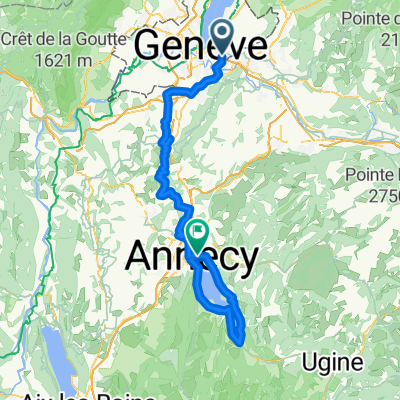 Genève - Annecy (tour du lac) - Genève
- Distance
- 104.8 km
- Ascent
- 921 m
- Descent
- 880 m
- Location
- Chêne-Bourg, Canton of Geneva, Switzerland
 TCS TdC : parcours argent
- Distance
- 92.8 km
- Ascent
- 810 m
- Descent
- 811 m
- Location
- Chêne-Bourg, Canton of Geneva, Switzerland
 Saint-Cergues - Champéry
- Distance
- 93.8 km
- Ascent
- 1,486 m
- Descent
- 890 m
- Location
- Chêne-Bourg, Canton of Geneva, Switzerland
Open it in the app