

PERCORSO STRADA 1a edizione CICLISTI & BICI
A cycling route starting in Fornacette, Tuscany, Italy.
Overview
About this route
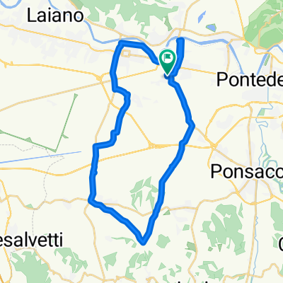
<p>
<b>START: Fornacette stand structure</b></p>
<p>
via di gello - lavaiano - 4 strade perignano - crespina - botteghino - fauglia - poggio pallone - collesalvetti - via delle sorgenti - livorno - stagno - viale americani - via aurelia sud - pisa airport - darsena area - traffic light via delle cascine - pisa - via del brennero - la fontina - colignola - mezzana - caprona - uliveto terme - lugnano - cascina - arnaccio roundabout</p>
<p>
<strong>FINISH: Fornacette stand structure (delicious refreshment)</strong></p>
Translated, show original (Italian)- -:--
- Duration
- 79 km
- Distance
- 249 m
- Ascent
- 250 m
- Descent
- ---
- Avg. speed
- ---
- Max. altitude

Route quality
Waytypes & surfaces along the route
Waytypes
Road
14.2 km
(18 %)
Quiet road
6.3 km
(8 %)
Surfaces
Paved
34.8 km
(44 %)
Unpaved
6.3 km
(8 %)
Asphalt
32.4 km
(41 %)
Gravel
4 km
(5 %)
Continue with Bikemap
Use, edit, or download this cycling route
You would like to ride PERCORSO STRADA 1a edizione CICLISTI & BICI or customize it for your own trip? Here is what you can do with this Bikemap route:
Free features
- Save this route as favorite or in collections
- Copy & plan your own version of this route
- Sync your route with Garmin or Wahoo
Premium features
Free trial for 3 days, or one-time payment. More about Bikemap Premium.
- Navigate this route on iOS & Android
- Export a GPX / KML file of this route
- Create your custom printout (try it for free)
- Download this route for offline navigation
Discover more Premium features.
Get Bikemap PremiumFrom our community
Other popular routes starting in Fornacette
 Campo di Croce-Santallago-Rai-Cristalli-Lombardone-Verruca
- Distance
- 41.8 km
- Ascent
- 980 m
- Descent
- 980 m
- Location
- Fornacette, Tuscany, Italy
 Lavaiano Cenaia Fornacette
- Distance
- 31 km
- Ascent
- 77 m
- Descent
- 131 m
- Location
- Fornacette, Tuscany, Italy
 Serrahero Domenica
- Distance
- 82.7 km
- Ascent
- 2,364 m
- Descent
- 2,365 m
- Location
- Fornacette, Tuscany, Italy
 monte serra
- Distance
- 44.7 km
- Ascent
- 981 m
- Descent
- 984 m
- Location
- Fornacette, Tuscany, Italy
 monte serra
- Distance
- 15.9 km
- Ascent
- 177 m
- Descent
- 180 m
- Location
- Fornacette, Tuscany, Italy
 Acqedotto Nottolini
- Distance
- 52.3 km
- Ascent
- 1,037 m
- Descent
- 1,035 m
- Location
- Fornacette, Tuscany, Italy
 Cavalli Tagliafuoco Verruca
- Distance
- 31.8 km
- Ascent
- 544 m
- Descent
- 544 m
- Location
- Fornacette, Tuscany, Italy
 Montecatini V.d.C. - Miemo
- Distance
- 127.6 km
- Ascent
- 1,008 m
- Descent
- 1,008 m
- Location
- Fornacette, Tuscany, Italy
Open it in the app