

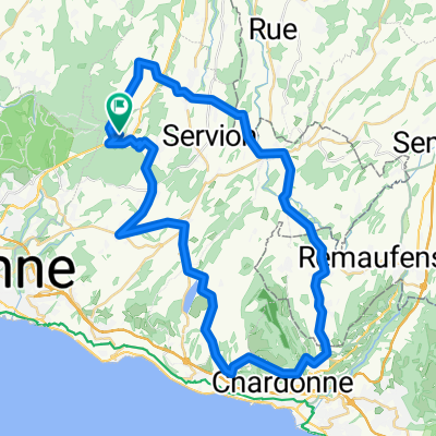
Parcours 50km
A cycling route starting in Froideville, Canton of Vaud, Switzerland.
Overview
About this route
Tour Montpreveyres, Mont-Pélerin, Montpreveyres
- -:--
- Duration
- 50 km
- Distance
- 552 m
- Ascent
- 551 m
- Descent
- ---
- Avg. speed
- ---
- Max. altitude
Route quality
Waytypes & surfaces along the route
Waytypes
Road
19 km
(38 %)
Quiet road
15 km
(30 %)
Surfaces
Paved
19 km
(38 %)
Unpaved
0.5 km
(1 %)
Asphalt
19 km
(38 %)
Ground
0.5 km
(1 %)
Undefined
30.5 km
(61 %)
Continue with Bikemap
Use, edit, or download this cycling route
You would like to ride Parcours 50km or customize it for your own trip? Here is what you can do with this Bikemap route:
Free features
- Save this route as favorite or in collections
- Copy & plan your own version of this route
- Sync your route with Garmin or Wahoo
Premium features
Free trial for 3 days, or one-time payment. More about Bikemap Premium.
- Navigate this route on iOS & Android
- Export a GPX / KML file of this route
- Create your custom printout (try it for free)
- Download this route for offline navigation
Discover more Premium features.
Get Bikemap PremiumFrom our community
Other popular routes starting in Froideville
 Trail tour n.18
- Distance
- 20.4 km
- Ascent
- 207 m
- Descent
- 207 m
- Location
- Froideville, Canton of Vaud, Switzerland
 Tour Montpreveyres_Mont-Pélerin_Montpreveyres 49km
- Distance
- 49.3 km
- Ascent
- 627 m
- Descent
- 628 m
- Location
- Froideville, Canton of Vaud, Switzerland
 Tour broyard
- Distance
- 80 km
- Ascent
- 688 m
- Descent
- 689 m
- Location
- Froideville, Canton of Vaud, Switzerland
 Parcours 50km
- Distance
- 50 km
- Ascent
- 552 m
- Descent
- 551 m
- Location
- Froideville, Canton of Vaud, Switzerland
 De Chemin du Closel 1, Froideville à Chemin du Closel 2F, Froideville
- Distance
- 7.2 km
- Ascent
- 127 m
- Descent
- 126 m
- Location
- Froideville, Canton of Vaud, Switzerland
 Tour par la Vallée de Joux
- Distance
- 133.9 km
- Ascent
- 1,472 m
- Descent
- 1,472 m
- Location
- Froideville, Canton of Vaud, Switzerland
 Boucle 52 km
- Distance
- 52.3 km
- Ascent
- 702 m
- Descent
- 703 m
- Location
- Froideville, Canton of Vaud, Switzerland
 De Chemin du Bas de Lavaux, Lausanne à Chemin du Closel 2C, Froideville
- Distance
- 9.7 km
- Ascent
- 501 m
- Descent
- 427 m
- Location
- Froideville, Canton of Vaud, Switzerland
Open it in the app