

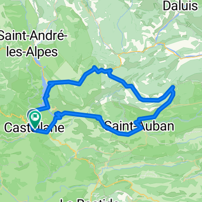
Etape 14 St André les Alpes -> Aiguines
A cycling route starting in Castellane, Provence-Alpes-Côte d'Azur Region, France.
Overview
About this route
St André les Alpes -> Aiguines
- -:--
- Duration
- 65.2 km
- Distance
- 649 m
- Ascent
- 1,048 m
- Descent
- ---
- Avg. speed
- ---
- Max. altitude

Route quality
Waytypes & surfaces along the route
Waytypes
Busy road
58.5 km
(90 %)
Track
4.4 km
(7 %)
Surfaces
Paved
58.6 km
(90 %)
Unpaved
4.7 km
(7 %)
Asphalt
58.6 km
(90 %)
Ground
2.4 km
(4 %)
Continue with Bikemap
Use, edit, or download this cycling route
You would like to ride Etape 14 St André les Alpes -> Aiguines or customize it for your own trip? Here is what you can do with this Bikemap route:
Free features
- Save this route as favorite or in collections
- Copy & plan your own version of this route
- Sync your route with Garmin or Wahoo
Premium features
Free trial for 3 days, or one-time payment. More about Bikemap Premium.
- Navigate this route on iOS & Android
- Export a GPX / KML file of this route
- Create your custom printout (try it for free)
- Download this route for offline navigation
Discover more Premium features.
Get Bikemap PremiumFrom our community
Other popular routes starting in Castellane
 Allauch 9. Etappe
- Distance
- 122.8 km
- Ascent
- 1,204 m
- Descent
- 1,660 m
- Location
- Castellane, Provence-Alpes-Côte d'Azur Region, France
 42 km Le Bourget - Gorges du Verdon
- Distance
- 42.1 km
- Ascent
- 515 m
- Descent
- 512 m
- Location
- Castellane, Provence-Alpes-Côte d'Azur Region, France
 RR Dingo Castel D4 93k
- Distance
- 92.3 km
- Ascent
- 3,352 m
- Descent
- 3,337 m
- Location
- Castellane, Provence-Alpes-Côte d'Azur Region, France
 RR Dingo Castel D2 110k
- Distance
- 115.4 km
- Ascent
- 4,983 m
- Descent
- 4,986 m
- Location
- Castellane, Provence-Alpes-Côte d'Azur Region, France
 RR Dingo Castel D1 81k
- Distance
- 81.7 km
- Ascent
- 2,305 m
- Descent
- 2,299 m
- Location
- Castellane, Provence-Alpes-Côte d'Azur Region, France
 Verdon - Kammroute Aussicht
- Distance
- 23.3 km
- Ascent
- 1,743 m
- Descent
- 1,741 m
- Location
- Castellane, Provence-Alpes-Côte d'Azur Region, France
 Verdonrunde groß
- Distance
- 100.8 km
- Ascent
- 1,498 m
- Descent
- 1,498 m
- Location
- Castellane, Provence-Alpes-Côte d'Azur Region, France
 6. Tag Trigance - Bauduen
- Distance
- 53.8 km
- Ascent
- 957 m
- Descent
- 1,255 m
- Location
- Castellane, Provence-Alpes-Côte d'Azur Region, France
Open it in the app