

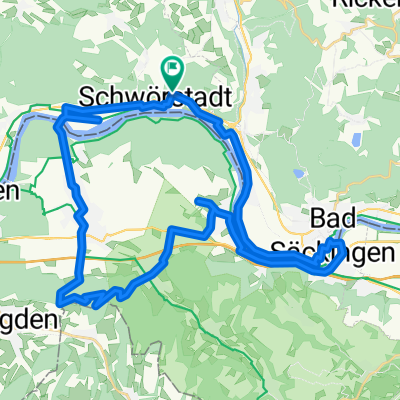
Sonnenbergroute über Bad Säckingen 39km 400h
A cycling route starting in Schwörstadt, Baden-Wurttemberg, Germany.
Overview
About this route
Tour from Schwörstadt to Sonnenberg with extreme incline. Good training.
(cloned from route 645274)(cloned from route 2702580)
- -:--
- Duration
- 39.2 km
- Distance
- 416 m
- Ascent
- 417 m
- Descent
- ---
- Avg. speed
- ---
- Max. altitude
Continue with Bikemap
Use, edit, or download this cycling route
You would like to ride Sonnenbergroute über Bad Säckingen 39km 400h or customize it for your own trip? Here is what you can do with this Bikemap route:
Free features
- Save this route as favorite or in collections
- Copy & plan your own version of this route
- Sync your route with Garmin or Wahoo
Premium features
Free trial for 3 days, or one-time payment. More about Bikemap Premium.
- Navigate this route on iOS & Android
- Export a GPX / KML file of this route
- Create your custom printout (try it for free)
- Download this route for offline navigation
Discover more Premium features.
Get Bikemap PremiumFrom our community
Other popular routes starting in Schwörstadt
 Sonnenbergroute über Bad Säckingen 39km 400h
- Distance
- 39.2 km
- Ascent
- 416 m
- Descent
- 417 m
- Location
- Schwörstadt, Baden-Wurttemberg, Germany
 Hauptstraße 157, Schwörstadt nach Hauptstraße 155, Schwörstadt
- Distance
- 40.6 km
- Ascent
- 335 m
- Descent
- 332 m
- Location
- Schwörstadt, Baden-Wurttemberg, Germany
 Wehr - Lörrach
- Distance
- 26.1 km
- Ascent
- 192 m
- Descent
- 181 m
- Location
- Schwörstadt, Baden-Wurttemberg, Germany
 Rundweg Wehr - Hasel - Dossenbach - Wallbach
- Distance
- 27.6 km
- Ascent
- 197 m
- Descent
- 197 m
- Location
- Schwörstadt, Baden-Wurttemberg, Germany
 Stage 2 Sumer 2020
- Distance
- 57.3 km
- Ascent
- 214 m
- Descent
- 137 m
- Location
- Schwörstadt, Baden-Wurttemberg, Germany
 Dinkelberg 1
- Distance
- 30.5 km
- Ascent
- 487 m
- Descent
- 493 m
- Location
- Schwörstadt, Baden-Wurttemberg, Germany
 2017 Schlussetappe
- Distance
- 103.2 km
- Ascent
- 384 m
- Descent
- 248 m
- Location
- Schwörstadt, Baden-Wurttemberg, Germany
 Sonnenbergroute über Bad Säckingen
- Distance
- 35.3 km
- Ascent
- 479 m
- Descent
- 479 m
- Location
- Schwörstadt, Baden-Wurttemberg, Germany
Open it in the app