

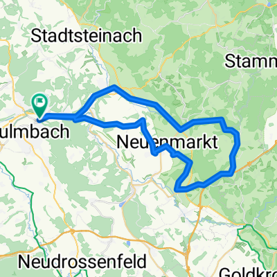
Kulmbach-Fränkische Schweiz
A cycling route starting in Kulmbach, Bavaria, Germany.
Overview
About this route
Kulmbach-Wonsees-Hollfeld-Aufsess-Plankenfels-Waischenfeld-Behringersmühle-Oberailsfeld-Glashütten-Mistelgau-Eckersdorf-Heinersreuth-Muckenreuth-Neuenreuth-Langenstadt-Kulmbach
- -:--
- Duration
- 112.7 km
- Distance
- 1,380 m
- Ascent
- 1,383 m
- Descent
- ---
- Avg. speed
- 548 m
- Max. altitude
Route quality
Waytypes & surfaces along the route
Waytypes
Road
16.9 km
(15 %)
Quiet road
10.1 km
(9 %)
Surfaces
Paved
69.9 km
(62 %)
Unpaved
2.3 km
(2 %)
Asphalt
68.7 km
(61 %)
Gravel
2.3 km
(2 %)
Continue with Bikemap
Use, edit, or download this cycling route
You would like to ride Kulmbach-Fränkische Schweiz or customize it for your own trip? Here is what you can do with this Bikemap route:
Free features
- Save this route as favorite or in collections
- Copy & plan your own version of this route
- Split it into stages to create a multi-day tour
- Sync your route with Garmin or Wahoo
Premium features
Free trial for 3 days, or one-time payment. More about Bikemap Premium.
- Navigate this route on iOS & Android
- Export a GPX / KML file of this route
- Create your custom printout (try it for free)
- Download this route for offline navigation
Discover more Premium features.
Get Bikemap PremiumFrom our community
Other popular routes starting in Kulmbach
 Main - Rhein Reise
- Distance
- 761.5 km
- Ascent
- 391 m
- Descent
- 645 m
- Location
- Kulmbach, Bavaria, Germany
 Kulmbach Wirsberg Hermes Kulmbach
- Distance
- 49.1 km
- Ascent
- 698 m
- Descent
- 695 m
- Location
- Kulmbach, Bavaria, Germany
 Von Kulmbach aus in die Fränkische Schweiz
- Distance
- 97.2 km
- Ascent
- 858 m
- Descent
- 814 m
- Location
- Kulmbach, Bavaria, Germany
 Расслабленный маршрут
- Distance
- 16.1 km
- Ascent
- 199 m
- Descent
- 245 m
- Location
- Kulmbach, Bavaria, Germany
 Kulmbach-Fränkische Schweiz
- Distance
- 112.7 km
- Ascent
- 1,380 m
- Descent
- 1,383 m
- Location
- Kulmbach, Bavaria, Germany
 Kulm Wirsb Himmelskron Neumarkt
- Distance
- 42.5 km
- Ascent
- 522 m
- Descent
- 522 m
- Location
- Kulmbach, Bavaria, Germany
 Sonntagsrunde
- Distance
- 44.9 km
- Ascent
- 214 m
- Descent
- 214 m
- Location
- Kulmbach, Bavaria, Germany
 Am Gründlein, Kulmbach nach Kettenbrückstraße, Bamberg
- Distance
- 89 km
- Ascent
- 791 m
- Descent
- 856 m
- Location
- Kulmbach, Bavaria, Germany
Open it in the app