

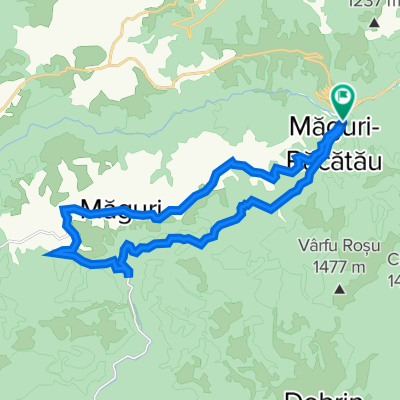
Tarnica túra
A cycling route starting in Măguri-Răcătău, Cluj County, Romania.
Overview
About this route
fhdhd
- -:--
- Duration
- 29.4 km
- Distance
- 688 m
- Ascent
- 689 m
- Descent
- ---
- Avg. speed
- ---
- Max. altitude

Continue with Bikemap
Use, edit, or download this cycling route
You would like to ride Tarnica túra or customize it for your own trip? Here is what you can do with this Bikemap route:
Free features
- Save this route as favorite or in collections
- Copy & plan your own version of this route
- Sync your route with Garmin or Wahoo
Premium features
Free trial for 3 days, or one-time payment. More about Bikemap Premium.
- Navigate this route on iOS & Android
- Export a GPX / KML file of this route
- Create your custom printout (try it for free)
- Download this route for offline navigation
Discover more Premium features.
Get Bikemap PremiumFrom our community
Other popular routes starting in Măguri-Răcătău
 Racatau - Maguri
- Distance
- 24.6 km
- Ascent
- 764 m
- Descent
- 738 m
- Location
- Măguri-Răcătău, Cluj County, Romania
 Valea Ursului
- Distance
- 8.1 km
- Ascent
- 412 m
- Descent
- 392 m
- Location
- Măguri-Răcătău, Cluj County, Romania
 Coada lacului- Tarnita-Lapusesti tur
- Distance
- 29.3 km
- Ascent
- 713 m
- Descent
- 714 m
- Location
- Măguri-Răcătău, Cluj County, Romania
 Maguri Racatau - defileul Somesului - Dobrin - Ghermanesti - Maguri Racatau
- Distance
- 32.6 km
- Ascent
- 1,034 m
- Descent
- 1,037 m
- Location
- Măguri-Răcătău, Cluj County, Romania
 Piatra Grosilor - Runcului, acces din Valea Ierii
- Distance
- 62.9 km
- Ascent
- 1,436 m
- Descent
- 919 m
- Location
- Măguri-Răcătău, Cluj County, Romania
 Colonia Marisel - Somesu Cald - Pape - Uzina - Somesu rece - Gilau - Luna de Sus - Floresti - Cluj-Napoca
- Distance
- 65.9 km
- Ascent
- 1,415 m
- Descent
- 1,529 m
- Location
- Măguri-Răcătău, Cluj County, Romania
 Maguri Racatau circuit
- Distance
- 22.2 km
- Ascent
- 666 m
- Descent
- 666 m
- Location
- Măguri-Răcătău, Cluj County, Romania
 Tarnica túra
- Distance
- 29.4 km
- Ascent
- 688 m
- Descent
- 689 m
- Location
- Măguri-Răcătău, Cluj County, Romania
Open it in the app