

Vigneti dell'Oltrepo: Voghera-Stefanago-Voghera
A cycling route starting in Voghera, Lombardy, Italy.
Overview
About this route
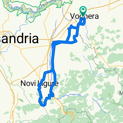
From the Voghera Station, one takes the Greenway, a bike path, until Codevilla. You turn uphill towards Torrazza Coste, then descend into the Val Schizzola, climbing the valley along the SP 20.After Schizzola, you turn left towards Stefanago and Fortunago; here the climb becomes quite difficult. After Stefanago, the road continues to ascend, alternating between hard sections and flat sections. Before the village of Fortunago, you take a steep side road that in Zebedo connects with the wide valley road (SP 203) towards Borgo Priolo. From there, you continue to Csa Coste, where you turn left, briefly continue uphill on the SP 20, turn right and ascend back towards Torrazza Coste. All that's left is to descend into the valley towards the Greenway or follow the local roadways to the Voghera station.
- -:--
- Duration
- 50.7 km
- Distance
- 479 m
- Ascent
- 476 m
- Descent
- ---
- Avg. speed
- ---
- Max. altitude

Route quality
Waytypes & surfaces along the route
Waytypes
Road
25.3 km
(50 %)
Cycleway
5.1 km
(10 %)
Surfaces
Paved
10.6 km
(21 %)
Asphalt
10.6 km
(21 %)
Undefined
40 km
(79 %)
Route highlights
Points of interest along the route

Point of interest after 24.3 km
Vigne e panorama da Stefanago
Continue with Bikemap
Use, edit, or download this cycling route
You would like to ride Vigneti dell'Oltrepo: Voghera-Stefanago-Voghera or customize it for your own trip? Here is what you can do with this Bikemap route:
Free features
- Save this route as favorite or in collections
- Copy & plan your own version of this route
- Sync your route with Garmin or Wahoo
Premium features
Free trial for 3 days, or one-time payment. More about Bikemap Premium.
- Navigate this route on iOS & Android
- Export a GPX / KML file of this route
- Create your custom printout (try it for free)
- Download this route for offline navigation
Discover more Premium features.
Get Bikemap PremiumFrom our community
Other popular routes starting in Voghera
 Voghera-Retorbido
- Distance
- 38.6 km
- Ascent
- 327 m
- Descent
- 241 m
- Location
- Voghera, Lombardy, Italy
 Colline del Gavi _ da Voghera
- Distance
- 104.5 km
- Ascent
- 619 m
- Descent
- 603 m
- Location
- Voghera, Lombardy, Italy
 Voghera=>Fortunago
- Distance
- 58.3 km
- Ascent
- 474 m
- Descent
- 470 m
- Location
- Voghera, Lombardy, Italy
 Vigneti dell'Oltrepo: Voghera-Stefanago-Voghera
- Distance
- 50.7 km
- Ascent
- 479 m
- Descent
- 476 m
- Location
- Voghera, Lombardy, Italy
 Tra Appennino e Po
- Distance
- 215.6 km
- Ascent
- 978 m
- Descent
- 995 m
- Location
- Voghera, Lombardy, Italy
 3cime Fortunago Costa Croce Alta Collina
- Distance
- 70.2 km
- Ascent
- 870 m
- Descent
- 868 m
- Location
- Voghera, Lombardy, Italy
 vogher-stazzano-voghera
- Distance
- 105.7 km
- Ascent
- 1,072 m
- Descent
- 1,071 m
- Location
- Voghera, Lombardy, Italy
 VogheraValStafforaOltrepòPavese
- Distance
- 40.4 km
- Ascent
- 659 m
- Descent
- 664 m
- Location
- Voghera, Lombardy, Italy
Open it in the app