

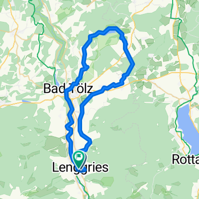
Lenggries - Walchensee - Sylvenstein See
A cycling route starting in Lenggries, Bavaria, Germany.
Overview
About this route
Beautiful flat Bavarian Alpine loop from Lenggries via 2 toll roads (free for cyclists) at Walchensee and along the Isar, past Sylvenstein Lake and back to Lenggries. You will climb about 420 meters of elevation. On weekends in good weather, the route along Walchensee is somewhat busy as bathers look for a spot to lay down. Otherwise, the loop rides very smoothly, with hardly any long climbs to tackle. For a stop, I recommend the Gasthof Post in Vorderriß with a nice beer garden and good food.
- -:--
- Duration
- 73.8 km
- Distance
- 337 m
- Ascent
- 326 m
- Descent
- ---
- Avg. speed
- ---
- Max. altitude

Route highlights
Points of interest along the route

Point of interest after 29.6 km
Der schöne Walchensee!

Point of interest after 30 km

Point of interest after 36.8 km
Bei Wallgau der Blick auf das Zugspitzmassiv!

Point of interest after 42.4 km

Point of interest after 45.3 km

Point of interest after 50.6 km
Zur Einkehr empfehle ich in Vorderriß den Gasthof Post mit einem schönen Biergarten und gutem Essen!
Continue with Bikemap
Use, edit, or download this cycling route
You would like to ride Lenggries - Walchensee - Sylvenstein See or customize it for your own trip? Here is what you can do with this Bikemap route:
Free features
- Save this route as favorite or in collections
- Copy & plan your own version of this route
- Sync your route with Garmin or Wahoo
Premium features
Free trial for 3 days, or one-time payment. More about Bikemap Premium.
- Navigate this route on iOS & Android
- Export a GPX / KML file of this route
- Create your custom printout (try it for free)
- Download this route for offline navigation
Discover more Premium features.
Get Bikemap PremiumFrom our community
Other popular routes starting in Lenggries
 Klosterrunde Sachsenkam - Kloster Reutberg
- Distance
- 50.9 km
- Ascent
- 478 m
- Descent
- 481 m
- Location
- Lenggries, Bavaria, Germany
 Um den Walchensee 65-400
- Distance
- 65.1 km
- Ascent
- 994 m
- Descent
- 1,013 m
- Location
- Lenggries, Bavaria, Germany
 Obergries - Aueralm - Obergries
- Distance
- 40.5 km
- Ascent
- 877 m
- Descent
- 875 m
- Location
- Lenggries, Bavaria, Germany
 An der Benewand entlang
- Distance
- 41.4 km
- Ascent
- 900 m
- Descent
- 908 m
- Location
- Lenggries, Bavaria, Germany
 2026_V2_ALPX_Brenner
- Distance
- 356 km
- Ascent
- 6,622 m
- Descent
- 7,235 m
- Location
- Lenggries, Bavaria, Germany
 Sonntraten
- Distance
- 4.4 km
- Ascent
- 362 m
- Descent
- 344 m
- Location
- Lenggries, Bavaria, Germany
 Lenggries nach Matrei a. Br. Gemeindeamt
- Distance
- 111.3 km
- Ascent
- 2,203 m
- Descent
- 1,895 m
- Location
- Lenggries, Bavaria, Germany
 RR Lenggries-Eng-Walchensee
- Distance
- 115.6 km
- Ascent
- 633 m
- Descent
- 630 m
- Location
- Lenggries, Bavaria, Germany
Open it in the app