

Killington Hill Repeat
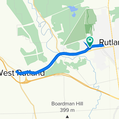
A cycling route starting in Rutland, Vermont, United States.
Overview
About this route
Go up and back down as long as you can!
A climb of 220m over 4km ( 722ft over 2.5mi), an average grade of 5.5%!- -:--
- Duration
- 8 km
- Distance
- 225 m
- Ascent
- 222 m
- Descent
- ---
- Avg. speed
- ---
- Max. altitude

Route highlights
Points of interest along the route
Point of interest after 4 km
Go back down...
Continue with Bikemap
Use, edit, or download this cycling route
You would like to ride Killington Hill Repeat or customize it for your own trip? Here is what you can do with this Bikemap route:
Free features
- Save this route as favorite or in collections
- Copy & plan your own version of this route
- Sync your route with Garmin or Wahoo
Premium features
Free trial for 3 days, or one-time payment. More about Bikemap Premium.
- Navigate this route on iOS & Android
- Export a GPX / KML file of this route
- Create your custom printout (try it for free)
- Download this route for offline navigation
Discover more Premium features.
Get Bikemap PremiumFrom our community
Other popular routes starting in Rutland
 Le Vermont à vélo, jour 2
- Distance
- 88.2 km
- Ascent
- 1,181 m
- Descent
- 1,193 m
- Location
- Rutland, Vermont, United States
 Aiming for 12
- Distance
- 18.4 km
- Ascent
- 161 m
- Descent
- 161 m
- Location
- Rutland, Vermont, United States
 Chittenden, VT, heavy hard up mt trail
- Distance
- 11.1 km
- Ascent
- 322 m
- Descent
- 38 m
- Location
- Rutland, Vermont, United States
 bkb
bkb- Distance
- 231.1 km
- Ascent
- 1,897 m
- Descent
- 2,307 m
- Location
- Rutland, Vermont, United States
 Killington Hill Repeat
- Distance
- 8 km
- Ascent
- 225 m
- Descent
- 222 m
- Location
- Rutland, Vermont, United States
 Columbian Avenue 196, Rutland to Columbian Avenue 194, Rutland
- Distance
- 12.4 km
- Ascent
- 51 m
- Descent
- 58 m
- Location
- Rutland, Vermont, United States
 KSR, Stage 3
- Distance
- 99.4 km
- Ascent
- 1,164 m
- Descent
- 759 m
- Location
- Rutland, Vermont, United States
 Wheelerville Road
- Distance
- 16.9 km
- Ascent
- 199 m
- Descent
- 238 m
- Location
- Rutland, Vermont, United States
Open it in the app