

TEUGE LANGS MOOI ZIC
A cycling route starting in Apeldoorn, Gelderland, The Netherlands.
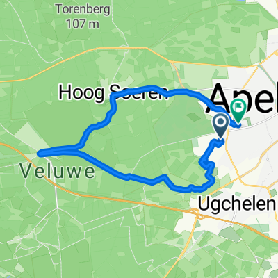
Overview
About this route
From Apeldoorn via a beautiful route to Teuge Airport.
Via Beemte and the Vecht.
Nice view of the airport along the way.
Picnic place.
Can be busy with other cyclists!
- -:--
- Duration
- 14.7 km
- Distance
- 8 m
- Ascent
- 30 m
- Descent
- ---
- Avg. speed
- ---
- Max. altitude

Route quality
Waytypes & surfaces along the route
Waytypes
Road
6.3 km
(43 %)
Cycleway
5.4 km
(37 %)
Surfaces
Paved
11.6 km
(79 %)
Unpaved
0.4 km
(3 %)
Asphalt
9.9 km
(67 %)
Concrete
1.8 km
(12 %)
Route highlights
Points of interest along the route
Point of interest after 12.6 km
MOOI UITZICHT NABEI VLIEGVELE TEUGE
Continue with Bikemap
Use, edit, or download this cycling route
You would like to ride TEUGE LANGS MOOI ZIC or customize it for your own trip? Here is what you can do with this Bikemap route:
Free features
- Save this route as favorite or in collections
- Copy & plan your own version of this route
- Sync your route with Garmin or Wahoo
Premium features
Free trial for 3 days, or one-time payment. More about Bikemap Premium.
- Navigate this route on iOS & Android
- Export a GPX / KML file of this route
- Create your custom printout (try it for free)
- Download this route for offline navigation
Discover more Premium features.
Get Bikemap PremiumFrom our community
Other popular routes starting in Apeldoorn
 Elspeet Molen
- Distance
- 37 km
- Ascent
- 156 m
- Descent
- 156 m
- Location
- Apeldoorn, Gelderland, The Netherlands
 rondje assel, hoog soeren
- Distance
- 17.9 km
- Ascent
- 98 m
- Descent
- 100 m
- Location
- Apeldoorn, Gelderland, The Netherlands
 Apeldoorn - Loenermark v.v.
- Distance
- 52.9 km
- Ascent
- 226 m
- Descent
- 228 m
- Location
- Apeldoorn, Gelderland, The Netherlands
 Apeldoorn 32km Aug 2014
- Distance
- 31.7 km
- Ascent
- 170 m
- Descent
- 169 m
- Location
- Apeldoorn, Gelderland, The Netherlands
 7314LE naar vliegveld Teuge
- Distance
- 14.8 km
- Ascent
- 8 m
- Descent
- 30 m
- Location
- Apeldoorn, Gelderland, The Netherlands
 rondje apeldoorn, hoog soeren, radio kootwijk
- Distance
- 29.3 km
- Ascent
- 320 m
- Descent
- 304 m
- Location
- Apeldoorn, Gelderland, The Netherlands
 bos, bos en nog meer bos
- Distance
- 33.7 km
- Ascent
- 342 m
- Descent
- 331 m
- Location
- Apeldoorn, Gelderland, The Netherlands
 rondje radio kootwijk
- Distance
- 29.7 km
- Ascent
- 521 m
- Descent
- 550 m
- Location
- Apeldoorn, Gelderland, The Netherlands
Open it in the app