

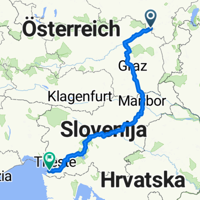
Radfreunde St.Johann 2014 Tag 2
A cycling route starting in Semmering, Lower Austria, Austria.
Overview
About this route
Semmering - Paffensattel - Rettenegg - Feistrititzsattel - St.Corona am Wechsel - Mönichkirchen - Hartberg bis Pöllau
- -:--
- Duration
- 119.5 km
- Distance
- 1,751 m
- Ascent
- 2,330 m
- Descent
- ---
- Avg. speed
- ---
- Max. altitude

Route quality
Waytypes & surfaces along the route
Waytypes
Busy road
102.7 km
(86 %)
Quiet road
5.5 km
(5 %)
Surfaces
Paved
94.5 km
(79 %)
Unpaved
1.8 km
(2 %)
Asphalt
93.8 km
(78 %)
Ground
1.2 km
(1 %)
Continue with Bikemap
Use, edit, or download this cycling route
You would like to ride Radfreunde St.Johann 2014 Tag 2 or customize it for your own trip? Here is what you can do with this Bikemap route:
Free features
- Save this route as favorite or in collections
- Copy & plan your own version of this route
- Split it into stages to create a multi-day tour
- Sync your route with Garmin or Wahoo
Premium features
Free trial for 3 days, or one-time payment. More about Bikemap Premium.
- Navigate this route on iOS & Android
- Export a GPX / KML file of this route
- Create your custom printout (try it for free)
- Download this route for offline navigation
Discover more Premium features.
Get Bikemap PremiumFrom our community
Other popular routes starting in Semmering
 Semmering-Izola
- Distance
- 476.6 km
- Ascent
- 1,082 m
- Descent
- 1,965 m
- Location
- Semmering, Lower Austria, Austria
 ALPEN 033: Semmering - Rust/Neusiedler See
- Distance
- 91.3 km
- Ascent
- 148 m
- Descent
- 998 m
- Location
- Semmering, Lower Austria, Austria
 fkhhj
fkhhj- Distance
- 69.3 km
- Ascent
- 2,234 m
- Descent
- 2,115 m
- Location
- Semmering, Lower Austria, Austria
 Hochschwab-túra
- Distance
- 238.6 km
- Ascent
- 4,805 m
- Descent
- 4,827 m
- Location
- Semmering, Lower Austria, Austria
 Radfreunde St.Johann 2014 Tag 2
- Distance
- 119.5 km
- Ascent
- 1,751 m
- Descent
- 2,330 m
- Location
- Semmering, Lower Austria, Austria
 Pinkenkogel
- Distance
- 39.3 km
- Ascent
- 1,446 m
- Descent
- 1,440 m
- Location
- Semmering, Lower Austria, Austria
 Semmering Panoramawandern Sonnwendstein - Hirschenkogel
- Distance
- 11.5 km
- Ascent
- 737 m
- Descent
- 737 m
- Location
- Semmering, Lower Austria, Austria
 Bahnhofstraße, Semmering nach Bahnstraße, Neunkirchen
- Distance
- 53.7 km
- Ascent
- 924 m
- Descent
- 1,448 m
- Location
- Semmering, Lower Austria, Austria
Open it in the app