

Vác - Árvaváralja (Oravsky Podzamok)
A cycling route starting in Vác, Pest County, Hungary.
Overview
About this route
It constantly climbs and ascends upwards. After Banská Bystrica, you have to cross the Low Tatras. The highest point of the route is around 1040 meters at Donovaly. There is a 17 km section that requires climbing after Banská Bystrica. The first 10 km of this are quite reasonable and comfortably doable. For the remaining 7 km, you need to prepare well. Experienced cyclists manage to climb it easily. For us, the extra 20 kg of gear also counted.
- -:--
- Duration
- 251.4 km
- Distance
- 1,449 m
- Ascent
- 1,045 m
- Descent
- ---
- Avg. speed
- ---
- Max. altitude

Route quality
Waytypes & surfaces along the route
Waytypes
Road
37.7 km
(15 %)
Quiet road
20.1 km
(8 %)
Surfaces
Paved
120.7 km
(48 %)
Asphalt
115.7 km
(46 %)
Concrete
5 km
(2 %)
Undefined
130.7 km
(52 %)
Route highlights
Points of interest along the route
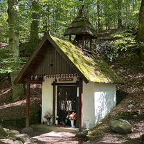
Point of interest after 116.5 km
12,5€/fő/éjszaka. Nagyon kellemes és igényes hely. Angolul jól tudnak. www.hanisberg.eu
Point of interest after 162.5 km
Pension Moyzes http://www.penzionmoyzes.sk/
Continue with Bikemap
Use, edit, or download this cycling route
You would like to ride Vác - Árvaváralja (Oravsky Podzamok) or customize it for your own trip? Here is what you can do with this Bikemap route:
Free features
- Save this route as favorite or in collections
- Copy & plan your own version of this route
- Split it into stages to create a multi-day tour
- Sync your route with Garmin or Wahoo
Premium features
Free trial for 3 days, or one-time payment. More about Bikemap Premium.
- Navigate this route on iOS & Android
- Export a GPX / KML file of this route
- Create your custom printout (try it for free)
- Download this route for offline navigation
Discover more Premium features.
Get Bikemap PremiumFrom our community
Other popular routes starting in Vác
 Mifa 901 Cic 🇭🇺🇩🇪
- Distance
- 33.1 km
- Ascent
- 322 m
- Descent
- 369 m
- Location
- Vác, Pest County, Hungary
 Vám utca, Vác - Vám utca, Vác
- Distance
- 66.8 km
- Ascent
- 626 m
- Descent
- 628 m
- Location
- Vác, Pest County, Hungary
 Harkály utca 7., Vác to Harkály utca 8., Vác
- Distance
- 11.2 km
- Ascent
- 227 m
- Descent
- 229 m
- Location
- Vác, Pest County, Hungary
 Vác Budapest közötti Duna két partján
- Distance
- 54.1 km
- Ascent
- 251 m
- Descent
- 251 m
- Location
- Vác, Pest County, Hungary
 Visszaállított útvonal
- Distance
- 33 km
- Ascent
- 278 m
- Descent
- 274 m
- Location
- Vác, Pest County, Hungary
 Vác - Szob Mifa 901 Cic🇭🇺🇩🇪
- Distance
- 35 km
- Ascent
- 325 m
- Descent
- 373 m
- Location
- Vác, Pest County, Hungary
 Vág utca, Vác nach Vág utca, Vác
- Distance
- 54.8 km
- Ascent
- 701 m
- Descent
- 705 m
- Location
- Vác, Pest County, Hungary
 Cil🇭🇺 Csepel Camping 🇭🇺 Cic Mifa 901 klapprad 🇩🇪
- Distance
- 29.9 km
- Ascent
- 177 m
- Descent
- 230 m
- Location
- Vác, Pest County, Hungary
Open it in the app