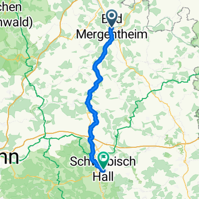
Rund um Bad Mergentheim
A cycling route starting in Bad Mergentheim, Baden-Württemberg, Germany.
Overview
About this route
Berg auf, Berg ab, Berg auf, Berg ab usw.
- -:--
- Duration
- 31.8 km
- Distance
- 778 m
- Ascent
- 752 m
- Descent
- ---
- Avg. speed
- ---
- Avg. speed
Route quality
Waytypes & surfaces along the route
Waytypes
Quiet road
9.8 km
(31 %)
Track
9.7 km
(30 %)
Surfaces
Paved
8.1 km
(26 %)
Unpaved
8.6 km
(27 %)
Asphalt
7.5 km
(23 %)
Gravel
3.7 km
(12 %)
Continue with Bikemap
Use, edit, or download this cycling route
You would like to ride Rund um Bad Mergentheim or customize it for your own trip? Here is what you can do with this Bikemap route:
Free features
- Save this route as favorite or in collections
- Copy & plan your own version of this route
- Sync your route with Garmin or Wahoo
Premium features
Free trial for 3 days, or one-time payment. More about Bikemap Premium.
- Navigate this route on iOS & Android
- Export a GPX / KML file of this route
- Create your custom printout (try it for free)
- Download this route for offline navigation
Discover more Premium features.
Get Bikemap PremiumFrom our community
Other popular routes starting in Bad Mergentheim
- Keltentour
- Distance
- 90.2 km
- Ascent
- 817 m
- Descent
- 815 m
- Location
- Bad Mergentheim, Baden-Württemberg, Germany
- Grünkern-Tour
- Distance
- 51.4 km
- Ascent
- 684 m
- Descent
- 685 m
- Location
- Bad Mergentheim, Baden-Württemberg, Germany
- Badeseen-Tour
- Distance
- 38.6 km
- Ascent
- 318 m
- Descent
- 318 m
- Location
- Bad Mergentheim, Baden-Württemberg, Germany
- Rothenburg o.T. - Berchtesgaden
- Distance
- 857.9 km
- Ascent
- 738 m
- Descent
- 370 m
- Location
- Bad Mergentheim, Baden-Württemberg, Germany
- Weinbau-Tour
- Distance
- 79.5 km
- Ascent
- 908 m
- Descent
- 905 m
- Location
- Bad Mergentheim, Baden-Württemberg, Germany
- Taubertal-Panorama Teil 2
- Distance
- 18.3 km
- Ascent
- 432 m
- Descent
- 444 m
- Location
- Bad Mergentheim, Baden-Württemberg, Germany
- Rund um Bad Mergentheim
- Distance
- 31.8 km
- Ascent
- 778 m
- Descent
- 752 m
- Location
- Bad Mergentheim, Baden-Württemberg, Germany
- Taubertal - Vorbachtal - Hohenlohe
- Distance
- 78.1 km
- Ascent
- 513 m
- Descent
- 508 m
- Location
- Bad Mergentheim, Baden-Württemberg, Germany