

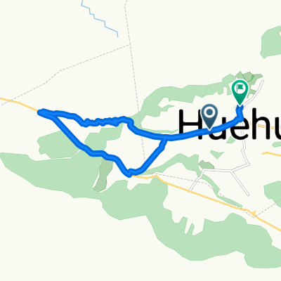
etapa 9 Zaculeu Huehuetenango Totonicapan Solola
A cycling route starting in Huehuetenango, Departamento de Huehuetenango, Guatemala.
Overview
About this route
Mountain 3 cat Malacatancito
1 cat Pologua
with volante San Francisco
with volante 4 roads
Mountain 1 cat Alaska
- -:--
- Duration
- 166.3 km
- Distance
- 2,161 m
- Ascent
- 1,908 m
- Descent
- ---
- Avg. speed
- ---
- Max. altitude

Continue with Bikemap
Use, edit, or download this cycling route
You would like to ride etapa 9 Zaculeu Huehuetenango Totonicapan Solola or customize it for your own trip? Here is what you can do with this Bikemap route:
Free features
- Save this route as favorite or in collections
- Copy & plan your own version of this route
- Split it into stages to create a multi-day tour
- Sync your route with Garmin or Wahoo
Premium features
Free trial for 3 days, or one-time payment. More about Bikemap Premium.
- Navigate this route on iOS & Android
- Export a GPX / KML file of this route
- Create your custom printout (try it for free)
- Download this route for offline navigation
Discover more Premium features.
Get Bikemap PremiumFrom our community
Other popular routes starting in Huehuetenango
 Huehuetenango- San Cristobal Verapaz
- Distance
- 155.2 km
- Ascent
- 2,950 m
- Descent
- 3,430 m
- Location
- Huehuetenango, Departamento de Huehuetenango, Guatemala
 De Unnamed Road a Unnamed Road
- Distance
- 4.4 km
- Ascent
- 86 m
- Descent
- 73 m
- Location
- Huehuetenango, Departamento de Huehuetenango, Guatemala
 De Huehuetenango a Huehuetenango
- Distance
- 14.3 km
- Ascent
- 157 m
- Descent
- 151 m
- Location
- Huehuetenango, Departamento de Huehuetenango, Guatemala
 GUA_ODC12
- Distance
- 78 km
- Ascent
- 854 m
- Descent
- 1,797 m
- Location
- Huehuetenango, Departamento de Huehuetenango, Guatemala
 De Huehuetenango a Unnamed Road, Huehuetenango
- Distance
- 25.1 km
- Ascent
- 666 m
- Descent
- 668 m
- Location
- Huehuetenango, Departamento de Huehuetenango, Guatemala
 huehuetenango-frontera Mexico
- Distance
- 85.3 km
- Ascent
- 726 m
- Descent
- 1,805 m
- Location
- Huehuetenango, Departamento de Huehuetenango, Guatemala
 E42F–Huehuetenango-Usupantan
- Distance
- 94.7 km
- Ascent
- 3,139 m
- Descent
- 5,032 m
- Location
- Huehuetenango, Departamento de Huehuetenango, Guatemala
 Ruta relajada en Huehuetenango
- Distance
- 22 km
- Ascent
- 677 m
- Descent
- 690 m
- Location
- Huehuetenango, Departamento de Huehuetenango, Guatemala
Open it in the app