A la découverte des Vosges du Nord - Boucle B
A cycling route starting in Ingwiller, Grand Est, France.
Overview
About this route
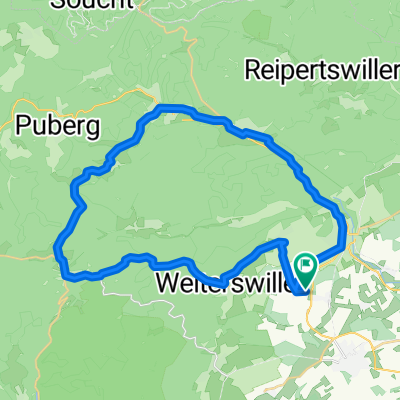
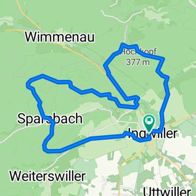
Le Parc Naturel Régional des Vosges du Nord is the starting point of this permanent hike. It straddles the departments of Bas-Rhin and Moselle. You will discover the beauty of its rich forests that cover nearly 80% of the 117,500 hectares of its total area, as well as its beautiful low-traffic roads. Circuit A, with slightly more rugged terrain, where you can admire the Alsatian plain, the Lorraine plateau, castles, and the reconstructed tour of the Chappe telegraph. On Circuit B, the waterways and ponds are more numerous. You can visit museums, crystal factories, and of course the numerous castles or ruins that dot the course and the Maginot Line that runs between Bitche and Lembach. Various Tourist Offices are at your disposal for further information.
- -:--
- Duration
- 153.5 km
- Distance
- 965 m
- Ascent
- 965 m
- Descent
- ---
- Avg. speed
- ---
- Max. altitude
Route quality
Waytypes & surfaces along the route
Waytypes
Road
52.2 km
(34 %)
Quiet road
15.3 km
(10 %)
Surfaces
Paved
116.6 km
(76 %)
Unpaved
3.1 km
(2 %)
Asphalt
116.6 km
(76 %)
Unpaved (undefined)
1.5 km
(1 %)
Continue with Bikemap
Use, edit, or download this cycling route
You would like to ride A la découverte des Vosges du Nord - Boucle B or customize it for your own trip? Here is what you can do with this Bikemap route:
Free features
- Save this route as favorite or in collections
- Copy & plan your own version of this route
- Split it into stages to create a multi-day tour
- Sync your route with Garmin or Wahoo
Premium features
Free trial for 3 days, or one-time payment. More about Bikemap Premium.
- Navigate this route on iOS & Android
- Export a GPX / KML file of this route
- Create your custom printout (try it for free)
- Download this route for offline navigation
Discover more Premium features.
Get Bikemap PremiumFrom our community
Other popular routes starting in Ingwiller
A la découverte des Vosges du Nord - Boucle B- Distance
- 153.5 km
- Ascent
- 965 m
- Descent
- 965 m
- Location
- Ingwiller, Grand Est, France
Rothbach 02-40km- Distance
- 39.2 km
- Ascent
- 758 m
- Descent
- 757 m
- Location
- Ingwiller, Grand Est, France
Rothbach 01-38Km- Distance
- 37.3 km
- Ascent
- 675 m
- Descent
- 672 m
- Location
- Ingwiller, Grand Est, France
Vélo 🚲- Distance
- 4.7 km
- Ascent
- 47 m
- Descent
- 49 m
- Location
- Ingwiller, Grand Est, France
Elsass_Tag3- Distance
- 57 km
- Ascent
- 526 m
- Descent
- 534 m
- Location
- Ingwiller, Grand Est, France
Rothbach 03-40km- Distance
- 40 km
- Ascent
- 735 m
- Descent
- 732 m
- Location
- Ingwiller, Grand Est, France
ASM_170602_v1- Distance
- 116.3 km
- Ascent
- 834 m
- Descent
- 839 m
- Location
- Ingwiller, Grand Est, France
3 Tour de France - Ingwiller _ Nancy- Distance
- 134.9 km
- Ascent
- 538 m
- Descent
- 524 m
- Location
- Ingwiller, Grand Est, France
Open it in the app


