

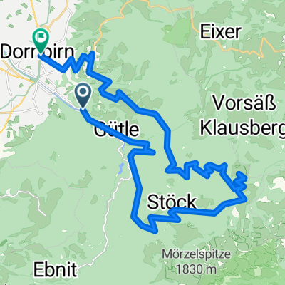
Dornbirn-Weissfluh-Kehlegg-Dornbirn
A cycling route starting in Dornbirn, Vorarlberg, Austria.
Overview
About this route
- -:--
- Duration
- 30.1 km
- Distance
- 968 m
- Ascent
- 1,003 m
- Descent
- ---
- Avg. speed
- ---
- Max. altitude

Route highlights
Points of interest along the route
Point of interest after 14.2 km
Continue with Bikemap
Use, edit, or download this cycling route
You would like to ride Dornbirn-Weissfluh-Kehlegg-Dornbirn or customize it for your own trip? Here is what you can do with this Bikemap route:
Free features
- Save this route as favorite or in collections
- Copy & plan your own version of this route
- Sync your route with Garmin or Wahoo
Premium features
Free trial for 3 days, or one-time payment. More about Bikemap Premium.
- Navigate this route on iOS & Android
- Export a GPX / KML file of this route
- Create your custom printout (try it for free)
- Download this route for offline navigation
Discover more Premium features.
Get Bikemap PremiumFrom our community
Other popular routes starting in Dornbirn
 Dannerbruck-Bühla Alp-Gräsa-Bregenzer Hütte-Bödele-Schwende-Eisenharz-Dannerbruck
- Distance
- 26.1 km
- Ascent
- 1,355 m
- Descent
- 1,352 m
- Location
- Dornbirn, Vorarlberg, Austria
 Dannerbruck-Eisenharz-Schauner-Schwende-und Retour
- Distance
- 11.6 km
- Ascent
- 498 m
- Descent
- 498 m
- Location
- Dornbirn, Vorarlberg, Austria
 Gütle-Rappenloch-Kobel-retour
- Distance
- 16 km
- Ascent
- 546 m
- Descent
- 548 m
- Location
- Dornbirn, Vorarlberg, Austria
 Dornbirn - Faschina – Bödele - Dornbirn
- Distance
- 99.9 km
- Ascent
- 1,874 m
- Descent
- 1,874 m
- Location
- Dornbirn, Vorarlberg, Austria
 Dornbirn-Weissfluh-Kehlegg-Dornbirn
- Distance
- 30.1 km
- Ascent
- 968 m
- Descent
- 1,003 m
- Location
- Dornbirn, Vorarlberg, Austria
 Dannerbruck-Kehlegg-Schwefel-Schauner-Schwende Alp-Eisenharz-Dannerbruck😅
- Distance
- 13.8 km
- Ascent
- 595 m
- Descent
- 592 m
- Location
- Dornbirn, Vorarlberg, Austria
 Dannerbruck- Kehlegg- Schwefel- Schauner- Schwendealp- und über Eisenharz retour zur Dannerbruck
- Distance
- 14.1 km
- Ascent
- 757 m
- Descent
- 708 m
- Location
- Dornbirn, Vorarlberg, Austria
 Dannerbruck - Gütle - Niedere - Kobelalpe und retour
- Distance
- 19.5 km
- Ascent
- 571 m
- Descent
- 575 m
- Location
- Dornbirn, Vorarlberg, Austria
Open it in the app