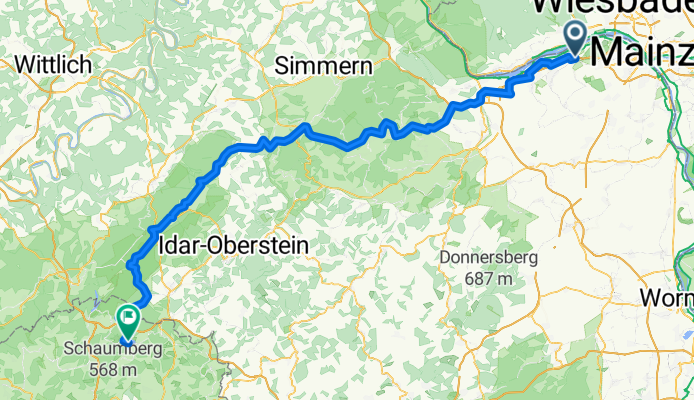
2014 4. Nightrider Triathlon über den Hunsrück zum Bostalsee
A cycling route starting in Wackernheim, Rhineland-Palatinate, Germany.
Overview
About this route
2014 4. Nightrider Triathlon über den Hunsrück zum Bostalsee
- -:--
- Duration
- 129.7 km
- Distance
- 1,132 m
- Ascent
- 818 m
- Descent
- ---
- Avg. speed
- ---
- Max. altitude
Route quality
Waytypes & surfaces along the route
Waytypes
Busy road
80.6 km
(62 %)
Road
24.5 km
(19 %)
Surfaces
Paved
114 km
(88 %)
Unpaved
1.6 km
(1 %)
Asphalt
109.1 km
(84 %)
Paved (undefined)
4.4 km
(3 %)
Continue with Bikemap
Use, edit, or download this cycling route
You would like to ride 2014 4. Nightrider Triathlon über den Hunsrück zum Bostalsee or customize it for your own trip? Here is what you can do with this Bikemap route:
Free features
- Save this route as favorite or in collections
- Copy & plan your own version of this route
- Split it into stages to create a multi-day tour
- Sync your route with Garmin or Wahoo
Premium features
Free trial for 3 days, or one-time payment. More about Bikemap Premium.
- Navigate this route on iOS & Android
- Export a GPX / KML file of this route
- Create your custom printout (try it for free)
- Download this route for offline navigation
Discover more Premium features.
Get Bikemap PremiumFrom our community
Other popular routes starting in Wackernheim
- Rennrad Tour
- Distance
- 108.3 km
- Ascent
- 675 m
- Descent
- 745 m
- Location
- Wackernheim, Rhineland-Palatinate, Germany
- Extensive Sonntag Route In Wackernheim
- Distance
- 22.5 km
- Ascent
- 215 m
- Descent
- 208 m
- Location
- Wackernheim, Rhineland-Palatinate, Germany
- 2014 4. Nightrider Triathlon über den Hunsrück zum Bostalsee
- Distance
- 129.7 km
- Ascent
- 1,132 m
- Descent
- 818 m
- Location
- Wackernheim, Rhineland-Palatinate, Germany
- TR Atzelnest mit langer Anfahrt
- Distance
- 99.7 km
- Ascent
- 833 m
- Descent
- 781 m
- Location
- Wackernheim, Rhineland-Palatinate, Germany
- TR_Wispertal mit anspruchsvoller Anfahrt
- Distance
- 118 km
- Ascent
- 1,143 m
- Descent
- 1,018 m
- Location
- Wackernheim, Rhineland-Palatinate, Germany
- Heidesheim-sprendlingen
- Distance
- 60.3 km
- Ascent
- 582 m
- Descent
- 582 m
- Location
- Wackernheim, Rhineland-Palatinate, Germany
- Jubiläums-Radtour 1250 Jahre Heidesheim
- Distance
- 18.4 km
- Ascent
- 51 m
- Descent
- 48 m
- Location
- Wackernheim, Rhineland-Palatinate, Germany
- 2015 eine neue Tradition ist geboren - Jahresabschlussfahrt zur Emmerichshütte - neunte Auflage
- Distance
- 89.7 km
- Ascent
- 561 m
- Descent
- 564 m
- Location
- Wackernheim, Rhineland-Palatinate, Germany
Open it in the app