
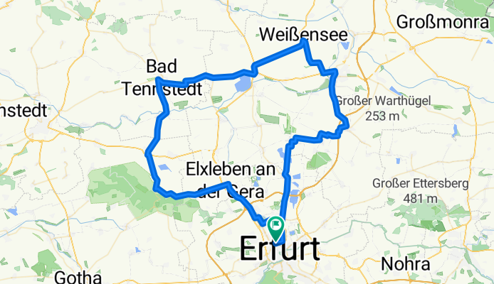
Erfurt - Bad Tennstedt - Sömmerda - Stotternheim - Erfurt
A cycling route starting in Erfurt, Free State of Thuringia, Germany.
Overview
About this route
Ausflug in den Norden Erfurts über Elxleben, Gierstädt nach Bad Tennstedt und Sömmerda; knappe 90 km, die man unterwegs durch zahlreiche Abänderungen auch variieren kann. Strecke ist eher flach, moderate Steigungen zwischen Witterda und Gierstädt wellenförmig, dann nach Döllstädt etwas rauf, ebenso vor Bad Tennstedt und nach Straußfurt. Komplett auf Asphalt.
- -:--
- Duration
- 92.2 km
- Distance
- 340 m
- Ascent
- 343 m
- Descent
- ---
- Avg. speed
- ---
- Avg. speed

Route quality
Waytypes & surfaces along the route
Waytypes
Busy road
49.6 km
(54 %)
Road
15.4 km
(17 %)
Surfaces
Paved
69.6 km
(75 %)
Unpaved
1.9 km
(2 %)
Asphalt
64.5 km
(70 %)
Paving stones
3.9 km
(4 %)
Continue with Bikemap
Use, edit, or download this cycling route
You would like to ride Erfurt - Bad Tennstedt - Sömmerda - Stotternheim - Erfurt or customize it for your own trip? Here is what you can do with this Bikemap route:
Free features
- Save this route as favorite or in collections
- Copy & plan your own version of this route
- Split it into stages to create a multi-day tour
- Sync your route with Garmin or Wahoo
Premium features
Free trial for 3 days, or one-time payment. More about Bikemap Premium.
- Navigate this route on iOS & Android
- Export a GPX / KML file of this route
- Create your custom printout (try it for free)
- Download this route for offline navigation
Discover more Premium features.
Get Bikemap PremiumFrom our community
Other popular routes starting in Erfurt
 Erfurt - Arn - Schmücke - Jonastal - Molsdorf - Erfurt
- Distance
- 102.6 km
- Ascent
- 1,045 m
- Descent
- 965 m
- Location
- Erfurt, Free State of Thuringia, Germany
 Lutherstein Tour
- Distance
- 45.8 km
- Ascent
- 133 m
- Descent
- 143 m
- Location
- Erfurt, Free State of Thuringia, Germany
 Tour zum Riechheimer Berg
- Distance
- 43 km
- Ascent
- 628 m
- Descent
- 559 m
- Location
- Erfurt, Free State of Thuringia, Germany
 Erfurt Westlich von Erfurt mit dem Rennrad
- Distance
- 52.3 km
- Ascent
- 222 m
- Descent
- 223 m
- Location
- Erfurt, Free State of Thuringia, Germany
 Erfurt - An der Gera
- Distance
- 31.1 km
- Ascent
- 91 m
- Descent
- 91 m
- Location
- Erfurt, Free State of Thuringia, Germany
 Rundfahrt Stefanrunde
- Distance
- 36.6 km
- Ascent
- 355 m
- Descent
- 355 m
- Location
- Erfurt, Free State of Thuringia, Germany
 Stadtradeln 04.06.2021
- Distance
- 57.7 km
- Ascent
- 148 m
- Descent
- 148 m
- Location
- Erfurt, Free State of Thuringia, Germany
 3 Gleichen Runde
- Distance
- 54.4 km
- Ascent
- 254 m
- Descent
- 259 m
- Location
- Erfurt, Free State of Thuringia, Germany
Open it in the app