

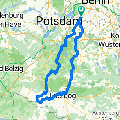
Berlepschstraße - Schenkenhorst - Caputh - Berlepschstraße
A cycling route starting in Zehlendorf, Land Berlin, Germany.
Overview
About this route
Von Zehlendorf gelangt man über Kleinmachnow und Stahnsdorf auf überwiegend gut befahrbaren Radwegen bis nach Güterfelde, von dort geht es an/auf der relativ wenig befahrenen Landstraße nach Schenkenhorst. Auf der asphalttechnisch gut beschaffenen Landstraße geht es über Nudow weiter nach Saarmund, von dort über Langerwisch weiter nach Michendorf, ab Langerwisch wird vorwiegend auf gut beschaffenen Fußwegen gefahren. Zwischen Michendorf und Caputh ist ein hervorragender Radweg verfügbar.
Caputh bietet gute Vorraussetzungen für ein kleines Päuschen im Schlosspark bzw. am Templiner See, auch eine Rundfahrt um den Caputher See (auf vorwiegend Waldwegen) ist zu empfehlen.
Von Caputh geht es auf einem Radweg Richtung Potsdam, auf dem es leider aufgrund von Überholmanövern oder Gegenverkehr etwas eng werden kann.
Durch die Potsdamer Innenstadt gelangt man über Radwege und später "Park-Straßen" bis zur Glienicker Brücke, dort beginnt ein längerer, jedoch nicht zu steiler Anstieg mit anschließender Bergabpassage. Die Tour führt auf der B1 weiter ggf. auf meist gut befahrbarem Radweg bis zum Hohentwielsteig. Auf dieser wenig befahrenen und sehr glatten Asphaltstraße ohne Radweg gelangt man schlussendlich wieder zum Startpunkt Ecke Idsteiner Straße - Berlepschstraße.
- -:--
- Duration
- 51.2 km
- Distance
- 184 m
- Ascent
- 179 m
- Descent
- ---
- Avg. speed
- 89 m
- Avg. speed

Route quality
Waytypes & surfaces along the route
Waytypes
Road
15.1 km
(29 %)
Busy road
14.8 km
(29 %)
Surfaces
Paved
46.3 km
(90 %)
Unpaved
0.4 km
(<1 %)
Asphalt
42.6 km
(83 %)
Paving stones
2.9 km
(6 %)
Continue with Bikemap
Use, edit, or download this cycling route
You would like to ride Berlepschstraße - Schenkenhorst - Caputh - Berlepschstraße or customize it for your own trip? Here is what you can do with this Bikemap route:
Free features
- Save this route as favorite or in collections
- Copy & plan your own version of this route
- Sync your route with Garmin or Wahoo
Premium features
Free trial for 3 days, or one-time payment. More about Bikemap Premium.
- Navigate this route on iOS & Android
- Export a GPX / KML file of this route
- Create your custom printout (try it for free)
- Download this route for offline navigation
Discover more Premium features.
Get Bikemap PremiumFrom our community
Other popular routes starting in Zehlendorf
 grunerunde
- Distance
- 31.4 km
- Ascent
- 181 m
- Descent
- 178 m
- Location
- Zehlendorf, Land Berlin, Germany
 Zehlendorf -> Fresdorf -> Caputh -> Teufelsberg
- Distance
- 85.4 km
- Ascent
- 298 m
- Descent
- 287 m
- Location
- Zehlendorf, Land Berlin, Germany
 Berlin - Dobbrikow - Fläming - Jüterbog - Berlin
- Distance
- 156.8 km
- Ascent
- 378 m
- Descent
- 381 m
- Location
- Zehlendorf, Land Berlin, Germany
 Grunewaldrund
- Distance
- 25.9 km
- Ascent
- 305 m
- Descent
- 301 m
- Location
- Zehlendorf, Land Berlin, Germany
 RTF 24. Eichh. 2. Runde
- Distance
- 40.5 km
- Ascent
- 112 m
- Descent
- 116 m
- Location
- Zehlendorf, Land Berlin, Germany
 Dahlem Route
- Distance
- 15.8 km
- Ascent
- 49 m
- Descent
- 52 m
- Location
- Zehlendorf, Land Berlin, Germany
 Flache Cross-Runde Berlin-Südwest
- Distance
- 42.1 km
- Ascent
- 114 m
- Descent
- 111 m
- Location
- Zehlendorf, Land Berlin, Germany
 Radtour Südlich von Berlin
- Distance
- 68.2 km
- Ascent
- 117 m
- Descent
- 117 m
- Location
- Zehlendorf, Land Berlin, Germany
Open it in the app