Rund um den Arber
A cycling route starting in Zwiesel, Bavaria, Germany.
Overview
About this route
very challenging mountains, great descents - especially in the Czech Republic and at Rittsteig beautiful views (if you still have the breath to enjoy them). Perhaps it would be even nicer via Hamry :o)
Start and finish: Zwiesel
- -:--
- Duration
- 109.3 km
- Distance
- 1,666 m
- Ascent
- 1,666 m
- Descent
- ---
- Avg. speed
- ---
- Max. altitude
Route quality
Waytypes & surfaces along the route
Waytypes
Road
10.9 km
(10 %)
Quiet road
8.7 km
(8 %)
Surfaces
Paved
83.1 km
(76 %)
Unpaved
1.1 km
(1 %)
Asphalt
83.1 km
(76 %)
Gravel
1.1 km
(1 %)
Undefined
25.1 km
(23 %)
Continue with Bikemap
Use, edit, or download this cycling route
You would like to ride Rund um den Arber or customize it for your own trip? Here is what you can do with this Bikemap route:
Free features
- Save this route as favorite or in collections
- Copy & plan your own version of this route
- Split it into stages to create a multi-day tour
- Sync your route with Garmin or Wahoo
Premium features
Free trial for 3 days, or one-time payment. More about Bikemap Premium.
- Navigate this route on iOS & Android
- Export a GPX / KML file of this route
- Create your custom printout (try it for free)
- Download this route for offline navigation
Discover more Premium features.
Get Bikemap PremiumFrom our community
Other popular routes starting in Zwiesel
- 5. Tschechienradtour 2002
- Distance
- 147.2 km
- Ascent
- 3,286 m
- Descent
- 3,079 m
- Location
- Zwiesel, Bavaria, Germany
- Rund um den Nationalpark
- Distance
- 127.3 km
- Ascent
- 1,189 m
- Descent
- 1,189 m
- Location
- Zwiesel, Bavaria, Germany
- Zwieses - Panoramaweg
- Distance
- 18.8 km
- Ascent
- 366 m
- Descent
- 366 m
- Location
- Zwiesel, Bavaria, Germany
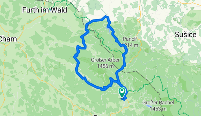
- zwiesel - gsenget - laka- alžbětín - rabenstein - zwiesel
- Distance
- 51.1 km
- Ascent
- 1,120 m
- Descent
- 1,120 m
- Location
- Zwiesel, Bavaria, Germany
- Zwiesel-Schachtenhaus-Hochschachten-Trinkw.-Oberzw.
- Distance
- 36 km
- Ascent
- 782 m
- Descent
- 737 m
- Location
- Zwiesel, Bavaria, Germany
- Stock und Stein Zwiesel - Deggendorf
- Distance
- 43.2 km
- Ascent
- 717 m
- Descent
- 963 m
- Location
- Zwiesel, Bavaria, Germany
- Großer Falkenstein Route 2
- Distance
- 18.1 km
- Ascent
- 833 m
- Descent
- 141 m
- Location
- Zwiesel, Bavaria, Germany
- Schachtentour
- Distance
- 53.7 km
- Ascent
- 1,169 m
- Descent
- 1,169 m
- Location
- Zwiesel, Bavaria, Germany
Open it in the app