

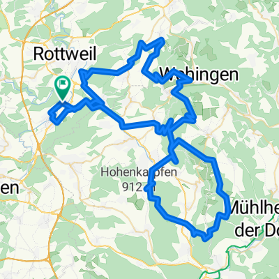
Deisslingen-Lauffen-Rottweil-Neufra-Aixheim-Tossingen-Deisslingen
A cycling route starting in Deißlingen, Baden-Württemberg, Germany.
Overview
About this route
Reine Mountainbikeroute mit Waldwegem, Schotterwegen und kurzem Trail
ca. 34 km, 467 Höhenmeter- -:--
- Duration
- 33.6 km
- Distance
- 313 m
- Ascent
- 315 m
- Descent
- ---
- Avg. speed
- ---
- Avg. speed
Route quality
Waytypes & surfaces along the route
Waytypes
Track
19.3 km
(57 %)
Quiet road
6.4 km
(19 %)
Surfaces
Paved
18.8 km
(56 %)
Unpaved
14 km
(42 %)
Asphalt
17 km
(51 %)
Gravel
12.6 km
(38 %)
Continue with Bikemap
Use, edit, or download this cycling route
You would like to ride Deisslingen-Lauffen-Rottweil-Neufra-Aixheim-Tossingen-Deisslingen or customize it for your own trip? Here is what you can do with this Bikemap route:
Free features
- Save this route as favorite or in collections
- Copy & plan your own version of this route
- Sync your route with Garmin or Wahoo
Premium features
Free trial for 3 days, or one-time payment. More about Bikemap Premium.
- Navigate this route on iOS & Android
- Export a GPX / KML file of this route
- Create your custom printout (try it for free)
- Download this route for offline navigation
Discover more Premium features.
Get Bikemap PremiumFrom our community
Other popular routes starting in Deißlingen
 MTB Tour Heuberg
- Distance
- 95.6 km
- Ascent
- 1,383 m
- Descent
- 1,383 m
- Location
- Deißlingen, Baden-Württemberg, Germany
 Hofwaldhütte
- Distance
- 5.5 km
- Ascent
- 131 m
- Descent
- 48 m
- Location
- Deißlingen, Baden-Württemberg, Germany
 Stockwald
- Distance
- 68.8 km
- Ascent
- 1,308 m
- Descent
- 1,305 m
- Location
- Deißlingen, Baden-Württemberg, Germany
 Rotenzimmern Waldenbachschlucht
- Distance
- 51.8 km
- Ascent
- 821 m
- Descent
- 820 m
- Location
- Deißlingen, Baden-Württemberg, Germany
 Lochenpass
- Distance
- 88.2 km
- Ascent
- 764 m
- Descent
- 764 m
- Location
- Deißlingen, Baden-Württemberg, Germany
 Weilersbach-Villingen-Marbach-Bad-Dürrheim-Schwenningen-Deisslingen
- Distance
- 44.6 km
- Ascent
- 237 m
- Descent
- 238 m
- Location
- Deißlingen, Baden-Württemberg, Germany
 Fürstenberg Tour
- Distance
- 58.1 km
- Ascent
- 536 m
- Descent
- 539 m
- Location
- Deißlingen, Baden-Württemberg, Germany
 Rote Steige
- Distance
- 33.7 km
- Ascent
- 423 m
- Descent
- 423 m
- Location
- Deißlingen, Baden-Württemberg, Germany
Open it in the app