

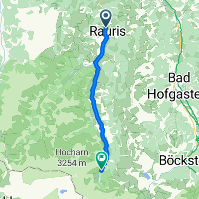
Rauriser Höhen Runde
A cycling route starting in Rauris, Salzburg, Austria.
Overview
About this route
Man fährt von Markt in Rauris weg. Fährt talauswärts biegt dann deim Gasthof Ager richtung Embach ab und fährt nach Embach rauf. Nach Embach gehts wieder runter richtung Lend (wo die Sonne nie Blend) man fährt auf der alten Bundesstraße richtung Taxenbach. Hier muss man auch einmal einen Kilometer auf der B311 fahren, was ein bissl lästig ist. In Taxenbach biegt man dann wieder Richtung Rauris ab und fährt über die Rauriser Höhe wieder heim. Dies ist vielleicht nicht die schönste Tour, aber ganz nett weil es etwas hügeliger ist und man deswegen ein bissl gefordert wird.
- -:--
- Duration
- 32.8 km
- Distance
- 750 m
- Ascent
- 769 m
- Descent
- ---
- Avg. speed
- 1,031 m
- Max. altitude

Route quality
Waytypes & surfaces along the route
Waytypes
Road
9.5 km
(29 %)
Quiet road
2.9 km
(9 %)
Surfaces
Paved
27.8 km
(85 %)
Unpaved
1 km
(3 %)
Asphalt
27.8 km
(85 %)
Unpaved (undefined)
0.7 km
(2 %)
Continue with Bikemap
Use, edit, or download this cycling route
You would like to ride Rauriser Höhen Runde or customize it for your own trip? Here is what you can do with this Bikemap route:
Free features
- Save this route as favorite or in collections
- Copy & plan your own version of this route
- Sync your route with Garmin or Wahoo
Premium features
Free trial for 3 days, or one-time payment. More about Bikemap Premium.
- Navigate this route on iOS & Android
- Export a GPX / KML file of this route
- Create your custom printout (try it for free)
- Download this route for offline navigation
Discover more Premium features.
Get Bikemap PremiumFrom our community
Other popular routes starting in Rauris
 Glockner Runde
- Distance
- 71 km
- Ascent
- 1,814 m
- Descent
- 1,810 m
- Location
- Rauris, Salzburg, Austria
 Liftweg 4, Rauris nach Rauris
- Distance
- 6 km
- Ascent
- 825 m
- Descent
- 21 m
- Location
- Rauris, Salzburg, Austria
 Kolm-Saigurn
- Distance
- 19.8 km
- Ascent
- 656 m
- Descent
- 33 m
- Location
- Rauris, Salzburg, Austria
 Rauris Miloš3
- Distance
- 45.6 km
- Ascent
- 1,022 m
- Descent
- 1,015 m
- Location
- Rauris, Salzburg, Austria
 Rauris: Krotmoosalm
- Distance
- 8.1 km
- Ascent
- 852 m
- Descent
- 15 m
- Location
- Rauris, Salzburg, Austria
 Rauris - Kolm Saigurn Naturfreundehaus
- Distance
- 20.6 km
- Ascent
- 702 m
- Descent
- 38 m
- Location
- Rauris, Salzburg, Austria
 Kolm Saigurn
- Distance
- 0.4 km
- Ascent
- 0 m
- Descent
- 12 m
- Location
- Rauris, Salzburg, Austria
 Mitterasten Rauris
- Distance
- 26.6 km
- Ascent
- 1,262 m
- Descent
- 437 m
- Location
- Rauris, Salzburg, Austria
Open it in the app