

Durchs Schwarze Land zum Wilh.-Raabe-Turm
A cycling route starting in Stadtoldendorf, Lower Saxony, Germany.
Overview
About this route
Start wie immer: An der Haustür.
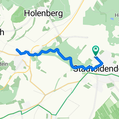
Über TENTRUS-EICHE um die Homburg nach LENNE. Am SCHWARZEN LAND geht es in den HILS, Anstieg bis zum Gasthaus ROTEN FUCHS auf ca. 360 Meter. Jetzt über 1,4 km zum Wilh.-Raabe-Turm (460m üNN). Zurück zum ROTEN FUCHS und die Asphaltstraße hinunter nach Holzen. Von hier über WICKENSEN und die HOMBURG zurück nach STADTOLDENDORF. Der Höhenmesser zeigte nach der Tour 633 gefahrene Höhenmeter.
- -:--
- Duration
- 30.3 km
- Distance
- 659 m
- Ascent
- 642 m
- Descent
- ---
- Avg. speed
- 460 m
- Max. altitude

Route quality
Waytypes & surfaces along the route
Waytypes
Track
20.6 km
(68 %)
Busy road
3.9 km
(13 %)
Surfaces
Paved
3.3 km
(11 %)
Unpaved
18.9 km
(62 %)
Gravel
17.2 km
(57 %)
Asphalt
2.8 km
(9 %)
Continue with Bikemap
Use, edit, or download this cycling route
You would like to ride Durchs Schwarze Land zum Wilh.-Raabe-Turm or customize it for your own trip? Here is what you can do with this Bikemap route:
Free features
- Save this route as favorite or in collections
- Copy & plan your own version of this route
- Sync your route with Garmin or Wahoo
Premium features
Free trial for 3 days, or one-time payment. More about Bikemap Premium.
- Navigate this route on iOS & Android
- Export a GPX / KML file of this route
- Create your custom printout (try it for free)
- Download this route for offline navigation
Discover more Premium features.
Get Bikemap PremiumFrom our community
Other popular routes starting in Stadtoldendorf
 Feierabendrunde - Um die Homburg
- Distance
- 21.3 km
- Ascent
- 480 m
- Descent
- 455 m
- Location
- Stadtoldendorf, Lower Saxony, Germany
 Durchs Schwarze Land zum Wilh.-Raabe-Turm
- Distance
- 30.3 km
- Ascent
- 659 m
- Descent
- 642 m
- Location
- Stadtoldendorf, Lower Saxony, Germany
 zur Weißen Mühle bei Lüdgenade
- Distance
- 21.5 km
- Ascent
- 184 m
- Descent
- 184 m
- Location
- Stadtoldendorf, Lower Saxony, Germany
 Zum Allersheimer MTB Cup nach Neuhaus i. Solling
- Distance
- 47.1 km
- Ascent
- 619 m
- Descent
- 606 m
- Location
- Stadtoldendorf, Lower Saxony, Germany
 Mardieksweg 5, Stadtoldendorf nach Mardieksweg 7, Stadtoldendorf
- Distance
- 16.4 km
- Ascent
- 363 m
- Descent
- 359 m
- Location
- Stadtoldendorf, Lower Saxony, Germany
 Vom Regen erwischt!
- Distance
- 11.5 km
- Ascent
- 181 m
- Descent
- 199 m
- Location
- Stadtoldendorf, Lower Saxony, Germany
 Homburgrunde
- Distance
- 8.3 km
- Ascent
- 453 m
- Descent
- 441 m
- Location
- Stadtoldendorf, Lower Saxony, Germany
 Stadtoldendorf-Großer Ahrensberg-Schorborn-Deensen
- Distance
- 28.9 km
- Ascent
- 373 m
- Descent
- 375 m
- Location
- Stadtoldendorf, Lower Saxony, Germany
Open it in the app