Steinheimrunde (bergig)
A cycling route starting in Ralingen, Rhineland-Palatinate, Germany.
Overview
About this route
Initially hilly, there are a few difficulties to overcome on the way, including the Côte de Oberglabach with a gradient of up to 17%. At the end, 30 km flat.
- -:--
- Duration
- 96.1 km
- Distance
- 682 m
- Ascent
- 682 m
- Descent
- ---
- Avg. speed
- ---
- Max. altitude
Route quality
Waytypes & surfaces along the route
Waytypes
Quiet road
13.5 km
(14 %)
Road
3.8 km
(4 %)
Surfaces
Paved
95.2 km
(99 %)
Asphalt
95.2 km
(99 %)
Undefined
1 km
(1 %)
Continue with Bikemap
Use, edit, or download this cycling route
You would like to ride Steinheimrunde (bergig) or customize it for your own trip? Here is what you can do with this Bikemap route:
Free features
- Save this route as favorite or in collections
- Copy & plan your own version of this route
- Split it into stages to create a multi-day tour
- Sync your route with Garmin or Wahoo
Premium features
Free trial for 3 days, or one-time payment. More about Bikemap Premium.
- Navigate this route on iOS & Android
- Export a GPX / KML file of this route
- Create your custom printout (try it for free)
- Download this route for offline navigation
Discover more Premium features.
Get Bikemap PremiumFrom our community
Other popular routes starting in Ralingen
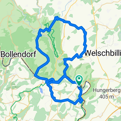
- Rosport (L) - Langsur (D)
- Distance
- 29.7 km
- Ascent
- 159 m
- Descent
- 157 m
- Location
- Ralingen, Rhineland-Palatinate, Germany
- enovos TriDays Bike Course 2020 Januar 2020
- Distance
- 89.6 km
- Ascent
- 573 m
- Descent
- 574 m
- Location
- Ralingen, Rhineland-Palatinate, Germany
- Tour de Luxembourg 2014, 2e etappe
- Distance
- 159.6 km
- Ascent
- 1,017 m
- Descent
- 814 m
- Location
- Ralingen, Rhineland-Palatinate, Germany
- Rosport
- Distance
- 9.9 km
- Ascent
- 299 m
- Descent
- 297 m
- Location
- Ralingen, Rhineland-Palatinate, Germany
- Steinheimrunde (bergig)
- Distance
- 96.1 km
- Ascent
- 682 m
- Descent
- 682 m
- Location
- Ralingen, Rhineland-Palatinate, Germany
- Luxemburg Tudor Tour 50km
- Distance
- 48.3 km
- Ascent
- 1,154 m
- Descent
- 1,153 m
- Location
- Ralingen, Rhineland-Palatinate, Germany
- Ralingen
- Distance
- 35.2 km
- Ascent
- 184 m
- Descent
- 179 m
- Location
- Ralingen, Rhineland-Palatinate, Germany
- Rosport Trier
- Distance
- 35 km
- Ascent
- 379 m
- Descent
- 415 m
- Location
- Ralingen, Rhineland-Palatinate, Germany
Open it in the app