Wola Zachariaszowska - Witkowice
A cycling route starting in Zielonki, Lesser Poland Voivodeship, Poland.
Overview
About this route
Szlak łatwy pozbawiony większych deniwelacji, prowadzący głównie drogami utwardzonymi i gruntowymi, o walorach krajobrazowych.
- -:--
- Duration
- 7 km
- Distance
- 36 m
- Ascent
- 110 m
- Descent
- ---
- Avg. speed
- ---
- Avg. speed
Route quality
Waytypes & surfaces along the route
Waytypes
Undefined
7 km
(100 %)
Surfaces
Undefined
7 km
(100 %)
Route highlights
Points of interest along the route
Point of interest after 3.1 km
Hotel Twierdza
Point of interest after 5.3 km
Centrum Integracji Społecznej w Zielonkach
Point of interest after 5.3 km
Mapa w Parku Wiejskim w Zielonkach
Continue with Bikemap
Use, edit, or download this cycling route
You would like to ride Wola Zachariaszowska - Witkowice or customize it for your own trip? Here is what you can do with this Bikemap route:
Free features
- Save this route as favorite or in collections
- Copy & plan your own version of this route
- Sync your route with Garmin or Wahoo
Premium features
Free trial for 3 days, or one-time payment. More about Bikemap Premium.
- Navigate this route on iOS & Android
- Export a GPX / KML file of this route
- Create your custom printout (try it for free)
- Download this route for offline navigation
Discover more Premium features.
Get Bikemap PremiumFrom our community
Other popular routes starting in Zielonki
- VI Rajd po gminie Zielonki
- Distance
- 30.5 km
- Ascent
- 394 m
- Descent
- 391 m
- Location
- Zielonki, Lesser Poland Voivodeship, Poland
- Zimowo super zamrożone.
- Distance
- 54 km
- Ascent
- 489 m
- Descent
- 487 m
- Location
- Zielonki, Lesser Poland Voivodeship, Poland
- pętelka na północ 105 k
- Distance
- 104.6 km
- Ascent
- 1,422 m
- Descent
- 1,411 m
- Location
- Zielonki, Lesser Poland Voivodeship, Poland
- pętelka treningowa
- Distance
- 47.6 km
- Ascent
- 634 m
- Descent
- 636 m
- Location
- Zielonki, Lesser Poland Voivodeship, Poland
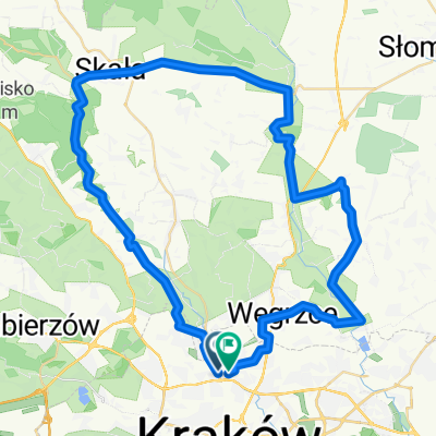
- Zielonki (szlak okrężny)
- Distance
- 32.6 km
- Ascent
- 351 m
- Descent
- 353 m
- Location
- Zielonki, Lesser Poland Voivodeship, Poland
- Wola Zachariaszowska- Witkowice
- Distance
- 7 km
- Ascent
- 31 m
- Descent
- 107 m
- Location
- Zielonki, Lesser Poland Voivodeship, Poland
- Szlak czerwony w gminie zielonki
- Distance
- 32.6 km
- Ascent
- 345 m
- Descent
- 345 m
- Location
- Zielonki, Lesser Poland Voivodeship, Poland
- Dolina Prądnika
- Distance
- 44.4 km
- Ascent
- 421 m
- Descent
- 421 m
- Location
- Zielonki, Lesser Poland Voivodeship, Poland