

Cicloturista Alcala la Real 2014
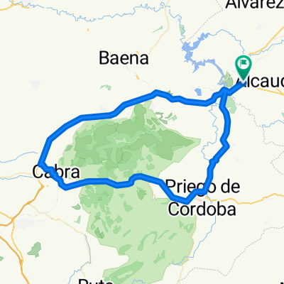
A cycling route starting in Alcaudete, Andalusia, Spain.
Overview
About this route
Cyclotourism event taking place through the Sierra Sur of Jaén, at a relaxed pace, with regrouping at many points and a timed section on the climb of Castillo de Locubín.
- -:--
- Duration
- 92.5 km
- Distance
- 1,330 m
- Ascent
- 1,331 m
- Descent
- ---
- Avg. speed
- ---
- Max. altitude

Route quality
Waytypes & surfaces along the route
Waytypes
Road
54.6 km
(59 %)
Quiet road
18.5 km
(20 %)
Surfaces
Paved
30.5 km
(33 %)
Asphalt
30.5 km
(33 %)
Undefined
62 km
(67 %)
Continue with Bikemap
Use, edit, or download this cycling route
You would like to ride Cicloturista Alcala la Real 2014 or customize it for your own trip? Here is what you can do with this Bikemap route:
Free features
- Save this route as favorite or in collections
- Copy & plan your own version of this route
- Split it into stages to create a multi-day tour
- Sync your route with Garmin or Wahoo
Premium features
Free trial for 3 days, or one-time payment. More about Bikemap Premium.
- Navigate this route on iOS & Android
- Export a GPX / KML file of this route
- Create your custom printout (try it for free)
- Download this route for offline navigation
Discover more Premium features.
Get Bikemap PremiumFrom our community
Other popular routes starting in Alcaudete
 Vuelta a la Subbética Cordobesa
- Distance
- 85.4 km
- Ascent
- 991 m
- Descent
- 984 m
- Location
- Alcaudete, Andalusia, Spain
 Alcaudete Chircales
- Distance
- 75.8 km
- Ascent
- 1,261 m
- Descent
- 1,263 m
- Location
- Alcaudete, Andalusia, Spain
 SierraSur_Recomendacion_03_Alcaudete_Martos_Casillas_Ahillos
- Distance
- 56.5 km
- Ascent
- 1,122 m
- Descent
- 1,122 m
- Location
- Alcaudete, Andalusia, Spain
 RUTA MOZARABE. Etapa 2
- Distance
- 83 km
- Ascent
- 572 m
- Descent
- 1,123 m
- Location
- Alcaudete, Andalusia, Spain
 25 Alcaudete to Puente de Genil
- Distance
- 80.7 km
- Ascent
- 549 m
- Descent
- 987 m
- Location
- Alcaudete, Andalusia, Spain
 AndenLucia 3 Alcaudete Iznalloz Guadix
- Distance
- 122.7 km
- Ascent
- 1,411 m
- Descent
- 983 m
- Location
- Alcaudete, Andalusia, Spain
 VÍA VERDE DEL ACEITE _ De JA-4308 50, Alcaudete a Calle del Pino 7, Jaén
- Distance
- 52.1 km
- Ascent
- 307 m
- Descent
- 269 m
- Location
- Alcaudete, Andalusia, Spain
 Cicloturista Alcala la Real 2014
- Distance
- 92.5 km
- Ascent
- 1,330 m
- Descent
- 1,331 m
- Location
- Alcaudete, Andalusia, Spain
Open it in the app